


Aルート(3.5km)を歩いてきました。(2015.05.27)
吹田市が設置した説明板では、『山並み、山道、池、水の流れをイメージした
吹田市が設置した説明板では、『山並み、山道、池、水の流れをイメージした
ルートで国立循環器病センター裏から千里遊歩道、北千里北公園を経て万博外周へ。
北千里遊歩道: 緑におおわれは自然道を散策しながら野鳥の声も楽しめ』


真っ直ぐに(南に)進むと、国立循環器センター
(岸辺に移転、2023年現在跡地は商業施設として再開発中です)
(2023.10.28現在、ドラッグストアや回転寿司店などすでに営業)
黒のフェンスを左に入ってゆきます。
黒のフェンスを左に入ってゆきます。

稜線に着くと三叉路、右(南)に進みます。

竹林の中の道、小刻みなアップダウンが続きます。

緑のネットワークルート以前の道標のようです。
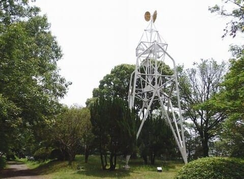
千里北公園の「風の道」
風により最上部の風車は当然廻りますが、上部の構造物も揺れます。
風により最上部の風車は当然廻りますが、上部の構造物も揺れます。

千里金蘭大学に降りてきました。ここからは車道歩きです。

阪大口BS

阪大前の水遠(ずいおん)池

車道脇の歩道を南下すると北消防署があり、そこを道標に従って左折します。
またこのような道標が…ここを写真右に行くと万博公園外周道路です。
またこのような道標が…ここを写真右に行くと万博公園外周道路です。
2017年頃?から閉鎖、R129(万博公園西信号)から左折迂回します。

万博公園外周道路に到着して終点となります。


※コメント投稿者のブログIDはブログ作成者のみに通知されます