


昨年の今頃歩いた、茨木の武士(もののふ)自然歩道から車作の道を掲載します。
この2~3年で代替宅地移転完了、付替道路工事(新府道46号線)が完成する
この2~3年で代替宅地移転完了、付替道路工事(新府道46号線)が完成する


桑原側からの登山口、付替道路工事で道が変わりここからしばらくは急登です。

阿武山頂上、南側稜線上に阿武山古墳(貴人の墓)があります。
埋葬された人物は、「大化の改新」の立役者の一人である中臣(藤原)
埋葬された人物は、「大化の改新」の立役者の一人である中臣(藤原)
鎌足だといわれています。

武士自然歩道の続きは右の階段を登って、しばらくは急登です。
左の林道車作線を直進すると車作の桜並木を経て竜仙峡に着きます。
左の林道車作線を直進すると車作の桜並木を経て竜仙峡に着きます。
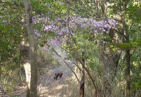
つつじの下にタヌキが、こちらを見ていました。

途中の高圧線鉄塔から萩谷の北大阪変電所の眺め
高槻・枚方の市街地の向こう右側に生駒山が霞んでいます。
高槻・枚方の市街地の向こう右側に生駒山が霞んでいます。

車作と萩谷(東海自然歩道)の分岐、左側の車作方向へ

竜仙の滝、看板には滝の高さ13mとありますが水量が少なく迫力がありません。

 車作高橋(旧阪急バス停)にあったダム計画図(2010.02.21撮影)
 「今昔マップ」による車作周辺安威川上流の新旧地図
(2022.11.18 地図追加 地図中青字は筆者記入 左旧、右新)

付け替え道路で新しく架けられた車作橋から見た車作の集落、その向こうに
竜王山を望みます。(2011.07.05撮影)
新府道46号の車作トンネルには専用歩道があり、車作から竜仙峡まですぐです。
新府道46号の車作トンネルには専用歩道があり、車作から竜仙峡まですぐです。


※コメント投稿者のブログIDはブログ作成者のみに通知されます