


利根川水系の河口付近
/ The Mouth of Tone River Water System
2020年6月10日 / June 10, 2020
こちらのページは、 Makki's Englishの利根川水系についての記事と連動しています。
This Page is related to My article on the Tone River in the site, "Makki's English" .
水系の地図については私の大好きなサイト;川の名前を調べる地図/ Site called "Maps for finding names of rivers" から、勝手に引用させていただいています。
 利根川の水源、大水上山(新潟と群馬の県境)から銚子(千葉県)までの主流の流れ。
The main stream of the Tone River, from the source, Mt. Ohminakami between Niigata Pref. and Gunma Pre.), to the mouth of the river, Choshi (Chiba Pref.).
16,840km²の水域を待つ利根川水系
The Tone River Water system having the vast watershed, 16,840km²

因みに、以前は利根川水系であったのに、現在は別水系になった荒川水系
The Arakawa River Water System, which used to be included in the Tone River Water System but not now.
霞ヶ浦~銚子あたりの利根川水系
The Tone River Water System, from Kasumigaura to Choshi

千葉県のマスコットチーバ君/ 横向きの形が千葉県の形そのままです!
Chiba Prefecture's Mascot called Chiba-kun, whose side-view figure is the same as the shape of Chiba Prefecture!

銚子の犬吠埼は、チーバ君の耳の先っぽにあります。
Cape Inubo in Choshi lies on the tip of the ear of Chiba-kun.


九十九里浜は、チーバ君の背中から後頭部の位置です。
Kujukuri-hama Beach lies from the back to the back of the head of Chiba-kun.
九十九里浜は全長約66㎞で、日本で2番目に長い砂浜海岸です。
堤防から海までが遠くて、海に近づかず…
しかも、海岸沿いに最も沿った「九十九里ビーチライン」(長生郡一宮町東浪見の国道128号~千葉県旭市下永井にある飯岡バイパス東までの全長約60kmの道路)という美しい道路の名前に惹かれ、ドライブすることにしたのですが…堤防のせいもあって、ほぼ海は見えず…途中は街中...
実は、九十九里有料道路を通らないと、海は見えなかったようです
The beach is approximately 66 kilometres long, making it the second longest beach in Japan.
ちばコレchannel > 千葉県の紹介 > Welcome to Chiba Prefecture!
の動画より…

↑九十九里の美し砂浜が雄大な太平洋に沿って延びています。
The beautiful sands of Kujukuri Beach line the grand Pacific Ocean.
*line=~に沿って並ぶ
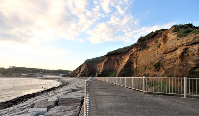
屛風ヶ浦Byobugaura Cliff (meaning Holding Screen Cliff)


景勝地として有名な屛風ヶ浦は、下総台地が海の波で削られた切り立った高さ20-60mの崖の事を指しているようです。
刑部岬(旭市)~犬岩(銚子市)まで約10km。下総台地が海の波によって削られてできた崖ですが、すごいのは、バームクーヘンのようなその地層‼
下の方の地層は300-100万年前の深い海で堆積したもの、上は訳10万年前の浅い海で堆積したものとのこと。
1960年代に消波ブロックが設置されるまでは、年間約50-100cmも浸食されていたとのこと。そのため、崖面に植物があまり生えず、縞模様が美しく見える崖が形成されたようです。
Byobugaura Cliff is a 20-60m-tall and 10km-long precipice from Cape Gyobu (in Asahi City) to Inuiwa Rock (in Choshi City).
Sea waves have eroded the Shimosa Plateau to create this precipice, whose lower strata were accumulated about 3-1 million years ago in the deep sea while upper about 100,000 years ago in the shallow ocean.
It used to be eroded at a rate of 50 to 100cm per year until wave-dissipating blocks were placed at the base of the cliff in the 1960s, so it is said that the beautiful stripes of strata are clearly seen without weeds growing on.
*precipice=プレスィピスゥ=崖、絶壁 (cliffよりも堅い語)
*erode=エロウドゥ=《自・他》浸食される、~を侵食する
*plateau=プらトウ=台地、高原
*strata=ストレイタ/ストラタ>stratum 層(=layer), 地層
*accumulate=アキュミュれイトゥ=《他・自》~を積み上げる、堆積する
*dissipate=ディスィペイトゥ=~を消す、無くなる(=disappear)
*wave-dissipating blocks=消波ブロック
*inlet=インれット=入江(bayより小さい)
実は、屛風ヶ浦は「浦」なのに、銚子のジオパークに着いたら「崖」そのものを指していたとわかりびっくり
しかも、崖を見られる遊歩道は、旭市の刑部岬側にはなく、銚子市まで行かなければ見れなかったのですが、市が違うせいか、観光案内が少なく、遊歩道まで辿り着くのに苦労しました
To tell the truth, Ura in Byobuga-ura means "bay" or "inlet", so I didn't know that the translation of Byobugaura is Byobugaura Cliff. (Byoubu means Holding Screen.)
From Cape Gyobu-misaki you can't see the cliff at all, because it is underneath. You can see the cliff from the walking trail in the east side in Choshi City, but there is no information about the trail near Cape Gyobu-misaki in Asahi City. I spent tough time to find the "Cliff Walking Trail"

行部岬は九十九里浜の最北端、銚子半島の南側、そして、屛風ヶ浦の西の端にあります。
Cape Gyobu-misaki is located at the very northern point of Kujukuri-hama beach, on the southern side of the Choshi Peninsula, and at the western end of the Byobugaura Cliff.
飯岡行部岬展望館前から九十九里浜方面を望む
You can see Kujukuri-hama beach from the top of Cape Gyobu-misaki.

銚子マリーナ海水浴場と屛風ヶ浦遊歩道
Choshi Marina Beach and Byoubugaura Cliff Walking Trail

千葉るるぶには、東洋のドーバー(ドーバー海峡に似ているため)と書いてありました。


犬吠埼の灯台Cape Inubousaki and the Inubousaki Lighthouse
明治7年、1874年に点灯した有名な灯台です。
普段は中を見学できますが、コロナで入場禁止でした。


何とホテルでペンギンが飼育されています
2羽はひな鳥で、羽毛がちょうど大人の毛に生え変わっているところ
There are five penguins at the hotel!! Two of them are babies whose feathers are changing now.


2020年6月11日 / June 11, 2020
ホテルから見た犬吠埼灯台と日の出 (4:40amごろ)
The Inubousaki Lighthouse and the rising sun seen from the hotel (around 4:40am)

犬吠埼は関東平野の最東端に位置するので、海からの美しい日の出を見るのに最適な場所です。
さらに地軸の関係(?)で、「日本で一番早くに初日の出を見られる場所」としても有名です。
この日は少し曇っていて、4:20amのはずの日の出を見ることができませんでした。
しかし、4:40am、雲のおかげで奇麗な写真を撮ることが出来ました
As Cape Inubousaki is located at the east end of the Kanto Plain, it is one of the best places to see the beautiful sunrise over the ocean.
It is also known as the place where you can see the earliest sunrise in Japan on New Year's Day.
Unfortunately it was a little bit cloudy, so I couldn't see the real sunrise at 4:20am.
But....it was lucky that I could see the round shape of the sun through the cloud above the ocean at 4:40am.

利根川河口
The mouth of the Tone River


河口から一番近い銚子大橋 (1,209m)
Choshi Ohashi Bridge (1,209m), the nearest bridge to the mouth of the Tone River


利根川河口堰 と常陸川水門
The Weir of the Mouth of the Tone River and Hitachi River Gate
上部は、利根川大橋(834m)の道路として利用されています。
There is a road (Tonegawa River Bridge/834m) on the gate.
* weir=ウイア/ウェア=堰(せき)、ダム≒dam=ダム、堰
*water gate/ flood gate=水門


利根川河口堰の上流は北浦~
霞ヶ浦(かすみがうら)は、琵琶湖についで日本で2番目に大きな湖で、実は、西浦・北浦・外浪逆浦(そとなさかうら)・北利根川・鰐川・常陸川の各水域の総体で、河川法では、この範囲が「常陸利根川」とされ、利根川の支川になるとのこと。
元々は「浦」という名前が示すように海の入り江に由来し、砂州や河川堆積物によって出口を閉ざされたラグーンで、時期や場所によって塩分濃度に違いはあるものの、かつての湖水は塩分が混じる汽水でした。特に1950~60年代に、下流の河川改修(浚渫)の影響で海水が遡上し、近年ではもっとも汽水化が進み、「汽水湖」というイメージが付いたそうです。
1963年に治水と塩害防止を目的に、常陸川水門(逆水門)が竣工され淡水化が進行し、今はほぼ淡水湖と変わらない状況にあるということです。
Lake Kasumigaura used to be a brackish-water lagoon, with indirect connections to the Pacific Ocean via the Hitachigawa and Tone Rivers.
It is the second-largest lake in Japan, located 60km to the north-east of Tokyo.
In a narrower sense, Lake Kasumigaura refers to a waterbody with an area of 167.63 km2. In a wider sense, it can refer to a group of contiguous lakes, which includes Lake Kasumigaura, hereby referred to as Nishiura , and two smaller lakes, Kitaura (35.16 km2) and Sotonasakaura (5.85 km2), and also encompasses the rivers connecting them. In this case the total area is 220 km2.
About 45% of the land surrounding the lake is natural landscape and 43.5% is agricultural land.
In 1963, the construction of a gate called Hitachi River Gate near the confluence of these rivers disconnected the lake from its sources of ocean water.
As a result, the salinity of Lake Kasumigaura declined, and today the lake contains almost fresh water.
*brackish=ブラキッシュ=汽水の/mixture of salty and fresh water
*lagoon=らグーンヌ=潟(かた)、礁湖(しょうこ)
*contiguous=コンティギュアス=接触している、隣接した、切れ目ない
*encompass=~を取り巻く(=surround)、~を含む(=include)
*the confluence=コンふるエンスゥ=合流(点)、合流した川
*salinity=ソりニティ=塩分、塩度
東国三社/ 香取神宮、鹿島神宮、息栖(いきす)神社
Three Great Shrines in eastern Japan/Katori Shrine, Kashima Shrine and Ikisu Shurine

鹿島神宮と北浦と西の一の鳥居の地図
Map of Kashima Shrine, Lake Kitaura and the First Shrine Gate of the east.

鹿島神宮西方、約2kmの大船津/北浦の水上にある西の一の鳥居
この巨大な水上鳥居は、実は平安時代からあったことが判明 平成25年(2013年)に再建されました。湖底からの高さ18.5mで現在日本で最も高い鳥居です。
(写真はGoogle Mapから)
The First Shrine Gate of the east of Kashima at Ofunatsu stands in Lake Kitaura.
It was found out that the shrine gate standing in Lake Kitaura existed even in Heian Period, about 1,000 years ago.
This gate was rebuilt in 2013, the tallest shrine gate standing in the water in Japan now. The height is 18.5m from the bottom of the lake.
(Pictures were copies of Google Map.)


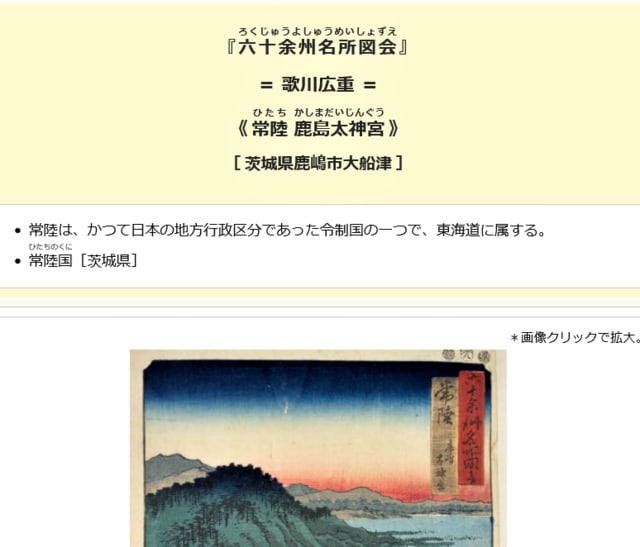
歌川広重(1797-1858)の絵にも西の一の鳥居が
The Ukiyoe Picture by Utagawa Hiroshige (1797-1858)
You can see the First Shrine Gate in the picture!!

江戸時代に盛況だった、利根川沿いの木下河岸から行徳に向かう木下街道(赤線)
利根川を利用して江戸の町と結んだ流通経路は、この部分だけ近道の陸路を(も?)利用したようです。
当時は超田舎だったはずの 白井や鎌ケ谷(鎌ヶ谷大仏)も、木下街道沿いの宿場町として栄えていたようです。
1678年に木下河岸の問屋が茶船の営業を開始して以後は、香取・鹿島・息栖の三社参りの遊覧客の来訪も盛んになったとのこと
Kioroshi Kaido Road (shown by the red line) used to be a very busy road!!
Please check out the following page for More Information about Kioroshi Kaido Road!!

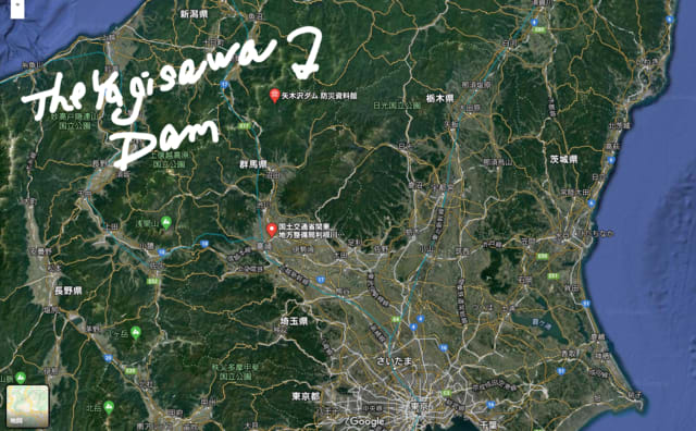
因みに、利根川の水利という意味で、有名な2つのダムの位置を載せておきます~~
Now I'd like to show you the location of two famous dams on the upper reaches of the Tone River just for your information.

八木沢ダム
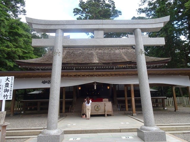
大鳥居 / Big Shrine Gate
2011年の東日本大震災で倒壊しましたが、2014年に地元の人達の協力で、境内に自生する樹齢500年~600年の杉の巨木を用いて再建されたそうです。
Though the gate fell down due to the devastaing eathquake in 2011, it was rebuilt with the support of local people in 2014. They say a 500~600-year-old cedar tree, having lived in the precinct of the shrine, was used to build the gate.


楼門 / Romon (Tower Gate)
1634年に水戸藩初代藩主の徳川頼房が奉納したとのこと。
熊本県の阿蘇神社、福岡県の筥崎(はこざき)宮と並ぶ日本3大楼門の1つです。
This tower gate was built in 1634 and one of the three greatest tower gates in Japan.


拝殿の奥が本殿で、1619年、徳川秀忠によって奉納されたとのこと。
国の重要文化財。
The main shrine stands backward. It was built in 1619 and is designated as an important cultural property.
拝殿の裏側に回って撮った写真


御手洗池 / Mitarashi-no-ike Pond
1日に40万リットル以上の湧水があり、昔は参拝する前にここで禊(みそぎ)をしていたそうです。
現在も、年始に200人もの人が大寒禊を行ったり、宮司や僧侶になる人が、修行(?)に使っているとのこと。
Worshipers used to purify themselves in this pond before visiting the main shrine.
400 thousand liters of spring water comes out everyday even now.

水郷佐原あやめパーク(千葉県)
Suigo Sawara Ayame Park (Sawara Riverside District Iris Park) in Chiba Prefecture


実は、ここに来るのにとても苦労しました。
利根川の北側が茨木県であると思っていたのですが、水郷佐原は利根川の北、常陸利根川の南にありました。
さらに、有名な水郷潮来あやめ園は、常陸利根川を渡って北側になります。

潮来大橋 Itako Ohashi Bridge
千葉県の水郷佐原から常陸利根川を渡って潮来方面に向かいます。
川の奥がすぐ、霞ヶ浦(西浦)になるようです。
Lake Kasumigaura (Nishiura) is forward.

水郷潮来アヤメ園(茨木県)
千葉県の水郷佐原あやめパークとは常陸利根川を挟んで反対側にあります。
とても近いところにあるのに、別の県になるので、宣伝広告も全く別…観光客にわかりにくいのがちょっと残念です
Suigo Itako Ayame Park (Itako Riverside District Park), Ibaragi Prefecture


※コメント投稿者のブログIDはブログ作成者のみに通知されます