On Saturday, August 12th, we first went to Mt. Zao for SOTA activation, but it was canceled due to heavy rain. I switched to castle sightseeing and SOTA activations at other mountains that I could drive up.
↓高つむじ山JA/YM-078での運用風景

↑Operation scene at Takatsumujiyama JA/YM-078
朝起きて小雨だったが、一応蔵王迄行ってみる事にした。
It was raining when I woke up in the morning, but I decided towent to Zao.
エコーラインの終点の駐車場迄行ってみたが、結構強い雨が降っている。
I went to the parking lot at the end of the Echo Line, but heavy raining.
お釜が見えるかもと駐車場のすぐ上の刈田岳山頂まで行ってみる。
I went to the summit of Mt. Karitadake just above the parking lot to see if I could see the 「Okama」.
↓刈田岳山頂から見た、雨の中の蔵王のお釜。

↑「Okama」 of Zao in the rain seen from the summit of Mt. Karitadake.
雨の中、お釜は見えるが、雨も強いので、熊野岳での無線運用はあきらめる。
I can see the「Okama」in the rain, but strong rain so I give up to activate at Mt. Kumanodake.
山形市内まで戻って、山形城址公園に行くことにする。
Return to Yamagata City and go to Yamagata Castle Ruins Park.
↓山形城址公園 本丸一文字門とお堀

↑Yamagata Castle Ruins Park Honmaru Ichimonji Gate and moat
↓城内にある山形市郷土館(お城印がここにある)

↑Yamagata City Local Museum in the park (the castle stamp is here)
お城印をゲットして、次の本庄市に行く途中でJA/YM-078高つむじ山693mへ。
Get a castle stamp and head to JA/YM-078 Takatsumujiyama 693m on the way to Honjo City.
ここは一応車で頂上まで行けるとの事前情報。途中から未舗装林道になり、いくらか荒れている所は有る物の長野の月蔵山や立山、先週登った音見山の林道に比べると全然問題ないレベルで登れる道だった。
The trail turns into an unpaved forest road, and there are some rough spots. However, compared to the forest roads of Mt. Gatsuzousan, Mt. Tateyama in Nagano, and Mt. Otomiyama that I climbed last week, it was an easy path to drive up.
↓無事に高つむじ山山頂到着。先端にグライダー用のスロープが有る。

↑Arrival at the mountaintop. There is a slope for gliders at the tip.
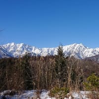
↓山頂から見た景色。

↑The view from the top of the mountain.
山頂には、単管で組んだ屋根のあるスペースが有るのでそこに機材を展開。
At the top, there is a shack made of iron pipes, so we deployed radio there.
↓無線機をセット

↑Prepare the radio
21MHzからCQ開始。
Start CQ from 21MHz.
しかし、台湾と北海道から呼ばれたのみ。
However, only called from Taiwan and Hokkaido.
18MHzにQSYするが、誰にも呼ばれない。
I QSY to 18MHz, but no one called.
14MHzにQSYすると、かろうじてJA局と2-QSO。
QSY to 14MHz, only 2-QSO with JA station.
↓アンテナの様子

↑Today's antenna
最後に7MHzでCQを出すが、今日は余り呼ばれず、9-QSO。
CQ on 7MHz, but I don't get many calls today, so only 9-QSOs.
XYLは2mと430のFMで何とか5-QSO。
XYL was 5-QSOs on 2m and 430 FM.
大きな町が近くにない山では、V/UのSSBは応答が無い様だ。
In the summit where there are no large towns nearby, V/U SSB is no response.
↓この日はずっと雨の中での運用となった。
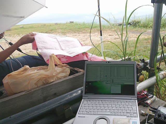
↑On this day, the operation was carried out in the rain.
今日は雨で蔵王に登れなかったので残念だった。
It was a pity that I couldn't climb Zao today because of the rain.
また、無線の方もDXは台湾1局、国内ももう一つで、ちょっと寂しい結果。
Also the radio, DX was only 1, and the CONDX in JA were bad, so there are few QSOs..
明日晴れたら、蔵王に再挑戦だな。
If it's sunny tomorrow, I'll try Zao again.
本日の結果 Today's result
21MHz/CW 2-QSO BV=1 included
18MHz/CW 0-QSO
14MHz/CW 2-QSO
7MHz/CW 9-QSO S2S(JA)=2 included
合計 Total 13-QSO
本日もお相手頂いたor追いかけて頂いた各局様有難うございました。
TNX for all stations who QSO with me or searching for me!
2023.8.12 (10/02 UP)