On August 1st (Sun), I went to SOTA activation at 1,887m JA/NN-215 Karei Kogen, in Ina City. My knee still hurts, but I try here where the altitude difference is only 50m short climbing.

ここは先週の陣馬形山同様にキャンプ場の先にピークがある。
Like last week's Jinbagatayama, there is a peak beyond the campsite.
残念ながら駐車場では標高差25m以内を満たさないので、一般駐車場から歩いてピークを目指す。
Unfortunately, the parking lot does not meet the altitude difference of 25m or less, so walk from the general parking lot and aim for the peak.
↓鹿嶺高原キャンプ場の看板。サミットはキャンプ場の先だ。

↑Signboard of Karei Kogen campsite.
↓ゲートのすぐ先に雷鳥荘。宿泊も出来る様だ。

↑Raichoso is just ahead of the gate. Can stay overnight by booking.
ちなみに、ゲート直前の駐車場は雷鳥荘利用者専用らしい。
The parking lot just before the gate is for Raichoso users.
↓ゲートの先には砂利道でキャンプ場へ

↑After through the gate, take the gravel road to the campsite.
↓途中左手の少し草の生えた道に入りキャンプ場へ。

↑On the way, enter the grassy road on my left and head to the campsite.
↓キャンプ場のネットの間を進む。ここはかなり草深い。
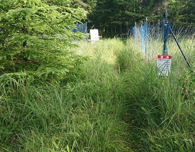
↑Proceed between the campsite nets. It's pretty grassy here.
↓キャンプ場を抜けるとトレッキングロードで坂を上がる。

↑After through the campsite, go up the slope on the trekking road.
↓尾根筋に出てしばらく平坦な道を進む。

↑Go out to the ridge and follow a flat road for a while.
↓サミット直前はまた少し坂を上る感じだ。

↑Just before the summit, going up the slope again.
↓去年はこれを三角点と勘違いしたがどうも違うらしい。

↑Last year I misunderstood this as a triangle point, but it seems that it is different.
↓少し先にも同じのが有った。境界見出標らしい。

↑There was the same thing a little later. There is a boundary marker.
↓2つの見出標の間にピークが有ったが三角点は無し。

↑There was a peak between the two heads, but no triangle point.
確かに地図にはここのピークの三角点は書かれていない。
Certainly, the map not show the triangle points of the peak here.
ピークのすぐ下に機材を展開する。
Prepare equipment just below the peak.
まずは先行局のFGL局、CTV局とS2S。
First of all, S2S QSO with FGL-sanand CTV-san.
その後14MHzからCQ。Then CQ from 14MHz.
台湾、インドネシア、ニュージーから呼ばれる。
Called by Taiwan, Indonesia and New Zealand.
国内も開けているようで、1,4,5,6,7,8からも呼ばれた。
The JA is also open, QSO with 1,4,5,6,7 and 8 area.
18MHzにQSYする前に、LHW局、CTV局、MHA局とS2S。
S2S-QSO with LHW-san, CTV-san and MHA-san before QSY to 18MHz.
↓本日のシャック

↑Today's shack
18MHzでは、ニュージーと国内の0,1,6,8から呼ばれた。
At 18MHz, called from New Zealand and JA 0,1,6 and 8 area.
その後QSYした21MHzは坊主だった。
After that, QSY to 21MHz but no called.
7MHzでは国内0,1,2,3,4,7,9エリアと交信。LCS局ともS2S。
At 7MHz, QSO with JA 0,1,2,3,4,7 and 9 areas. And S2S with LCS-san.
Xの方はV/UのSSB/FM共に余り応答がないようだ。
XYL seems to have little response in both SSB/FM at V/UHF.
でも昨年は2mSSBで2エリアと沢山出来てた気がするが、、、
But last year, she was able to make a lot of 2 areas with 2m SSB...
それでも4-Qはクリアし、フトノ峠へキノコ写真を撮りに行った。
Cleared 4-QSO then she went to Futono Pass to take a phot of mushroom.
↓10時頃から結構ガスに包まれる。

↑It is quite covered with gas from around 10 o'clock.
ここは林の中で、日射しが指さないので涼しく少し寒い位だ。
It's cool and a little cold here in the woods because the no sunlight.
地面もかなり湿っていて、あちこちでキノコが生えている。
The ground also quite damp and mushrooms are growing here and there.
天気がもう一つで今にも雨が降り出しそうなので、Xを呼び戻す。
The weather is little bad. Will rain soon, so I recall XYL.
遠くでは雷も鳴っているのが聞こえる。
In the distance, we can hear thunder.
戻って来て7MHz/SSBでCQ。0,1,3,4,7エリアとQSO。
She come back and CQ at 7MHz/SSB. QSO with JA 0,1,3,4 and 7 area.
一通り予定バンドをこなした所で雨も心配なので、急いで撤収。
Worried about rain. Finished the planned band, we hurriedly withdrew.
下山を開始した。(と言っても30分位だが)
We started to go down the mountain.
↓トレッキングコースは入笠山迄12km程続いて居る様だ。

↑The trekking course seems to continue for about 12km to Mt.Nyugasa.
↓下山途中にもキノコを見つけて写真。

↑She found a mushroom on the way down the mountain and took a phot.
途中で雨がポツポツ来たので急いで帰る。
It rained on the way, so we hurried to car.
↓なんとか本降りにはならず車に到着。後ろの電柱は携帯基地局。

↑The rain didn't get stronger by the time we returen to the car.
本日の結果 Today's result
14MHz/CW 22-QSO BV=1 YB=3 ZL=2 S2S=1(JA)included
18MHz/CW 9-QSO ZL=2 S2S=1(JA) included
21MHz/CW 0-QSO
7MHz/CW 12-QSO S2S=3(JA) included
7MHz/SSB 1-QSO S2S(JA)
合計 Total 42-QSO
本日もお相手頂いたor追いかけて頂いた各局様有難うございました。
TNX for all stations who QSO with me or searching for me!
2021.8.1 (8/3 UP)