Oct. 1st is anniversary of my company establishment. I went to JA/GF-001 Norikuradake Kengamine 3,026m for SOTA operation.
↓Shuttle bus stop.

乗鞍岳は1年中マイカー規制でなので、松本市安曇の乗鞍観光センター前(1,456m)からシャトルバスに乗って山頂近くの畳平まで行く。平日なのですいているかと思ったが、バス1台80%位の乗車率と、平日でも人が多い。紅葉のシーズンが始まるからか、、、
↓Shuttle bus for Mt.Norikura.

バスに揺られながら、50分程山道を登ると一気に2,704mの畳平バスターミナルに到着だ。

↑Shuttle bus end stop at Tatamidaira.
乗鞍岳とは、この辺りのいくつかのピークの総称なのだが、目指すのはSOTA指定されている最高峰の剣ケ峰だ。バスターミナルからは剣ケ峰は見えないが、たぶんあのドームの先の方に有るのだろう。剣ヶ峰を目指して、スタートだ。
↓The summit is beyond the dome.

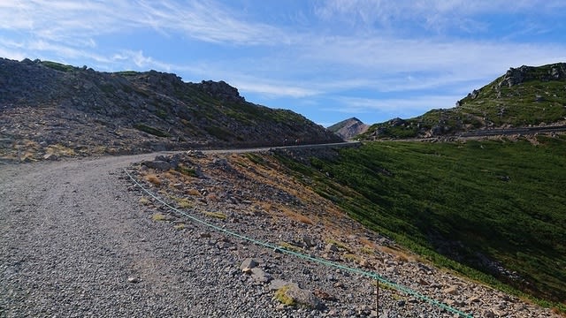
先ずは登山口の肩の小屋を目指して、緩い勾配の幅広い砂利道を行く。
↓Go on a wide gravel road with a gentle slope.
しばらく歩くと剣ヶ峰への案内看板。
↓Branch sign to Kengamine.

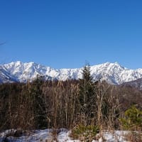
分岐から少し行くと、素晴らしい眺め!下界は雲海の中だ!
でも、紅葉はまだ始まったばかりで色づきはもう一つ。

↑Wonderful view with a short walk from the branch.
更に行くと、道が幾らか下った先に肩の小屋と剣ヶ峰の山が見えて来た。
↓Went further, could see the Kata no koya and Kengamine.

↑左端の頂の先が剣ヶ峰、右手前の淡い色の屋根が肩の小屋
↓Arrive at the Kata no koya(shoulder hut).

↑肩の小屋到着。ここ迄40分と登りが緩いのでほぼ標準タイム。
↓A little break at the rest area behind the hut.

↑小屋の裏手の休憩所で少し休憩。
↓ There is rental Stock.

↑ちなみに肩の小屋では、ストックレンタルもやっていた!
↓Enter the trail. Altitude difference 260m to Summit.

↑いよいよ登山道に入る。ここから山頂までの標高差は約260m。
↓The trail is rocky.

↑岩がゴロゴロした登山道を登る。
↓Sometimes look back and watching the scenery.

↑勾配のきつい所も何か所かあり、何度も立ち止まって、周りの風景を眺めながら、休み休み登る。
↓Climbing 40 min., could see the shrine torii of the summit.

↑40分弱登ると少し平らになり、頂きの先に小さく神社と鳥居が見えた。
おお、山頂までもう少しだ!
↓Sign of the shop of the summit hut.

↑山頂少し手前で、頂上小屋の売店の案内看板。そちらは後回しにして、右の頂上を先に目指す。
↓A little more to the top.

↑頂上までもう少し!再び急な岩の登りになる!最後の一踏ん張り!
↓Arrive at the summit.

↑山頂に到着、狭い山頂に結構たくさんの人がいる。
ここ迄、55分程掛かった。標準タイムの1割増しと言った所か、、、
↓Pray to Norikura Motomiya Shrine at the summit.

↑山頂の乗鞍本宮社にお参り。反対側には朝日権現社の祠も有る。
山頂が狭いのでどこでお店を広げるか迷ったが、朝日権現社側の登山道の端に境のロープを止める鉄製の杭?が立っていたので、それを利用して釣り竿を建てた。
↓Todays antenna and shack.

↑アンテナとシャックの全容。
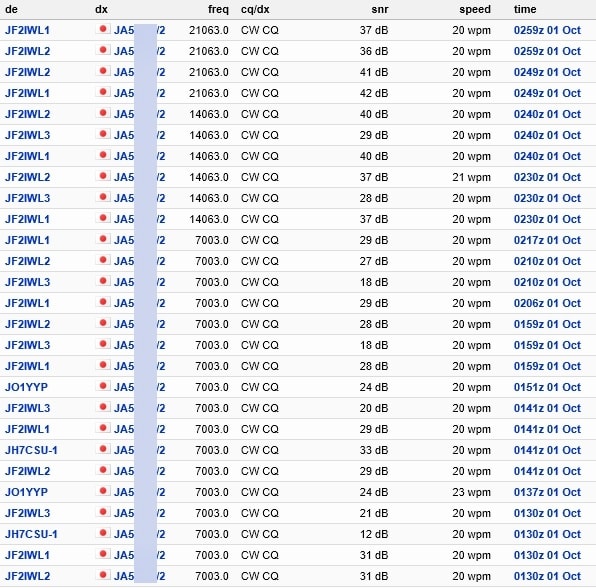
運用開始は10時30分頃から7MHzで開始。今回はSPOT出来なくても大丈夫な用に、アラートで運用周波数も告知して有ったので、2コール程で直ぐお声が掛かる。
平日なのでちょっと心配していたが、VVH局さんが早々にJクラにUPしてくれた様で、途中でパイルになりながらも、7MHzだけで28局と交信。
↓Uploaded to the cluster.

7MHzはコンディションも良く、6エリア以外、国内は全てつながった。
また、平日はお仕事だと思われるIOTさんも、なんと/7でコール頂いた。
7MHzで45分程運用後、14MHzに上がる。
こちらは、Chacer上位の常連局さんから呼んで頂いた。
21MHzでは、台湾のいつもの局長さんからもコール頂いた。
↓Condition is good. Many picked up by RBN skimmer.
↑国内は結構RBNにも拾われたようである。
その後はアンテナをV/Uに変更した。いつもは余り呼ばれないのだが、さすがに標高が高いので、多くはないけど、いつもより沢山呼ばれた。
途中、SPOTも上げていたのだが、430以降のSPOTを上げようとした時に何故かエラーが帰ってきてUP出来なかった。仕方なく、430と1.2GはノーSPOTで運用した。
と言う事で本日の交信結果は以下の通り。
7MHz/CW 28局(1~5、7~0エリア)
14MHz/CW 2局(1エリア)
21MHz/CW 2局(台湾と北海道)
50MHz/CW 2局(1,2エリア)
50MHz/SSB 0局
144MHz/CW 5局(1,2,0エリア)
430MHz/CW 2局(1,9エリア)
1.2GHz/FM 1局(2エリア)
合計 42局
↓Todays radio room.

↑シャックはいつもの様にこんな感じ。自分は岩に腰かけて運用。
↓バスの時間もあるので、1時過ぎには撤収を開始し、1時半に下山開始。

↑Starts descent at 13:30.
↓行きに寄らなかった、頂上小屋が足元に見える。

↑Could see the top hut.
↓頂上小屋では、色々とグッヅも売っていた。
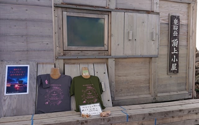
↑Norikura goods are on sale.
帰りは少しザクザクの石で滑りやすい所もあったが、概ね快調に降りて来られて、肩の小屋までが35分程。
↓

↑35min. to Kata no koya(shoulder hut).
↓肩の小屋~畳平間ではたくさんのホシガラスを見かけた。

↑There were many Hoshi crows
↓肩の小屋から畳平には33分程で到着。

↑Arrives in 33 min. from the Kata no koya(shoulder hut).
乗れないか?と思っていた3時のバスにも乗れ、観光センター前へ。
↓この後、すぐ目の前の湯けむり館で温泉に入ってから帰宅した。

↑Enter the hot spring near the base shuttle bus stop.
今回は、V/Uの最遠は、144MHzでの250km程となった。
休日なら他の局も移動局が多かったと思われるが、そこは平日なので、S2Sや高い所との遠距離通信は出来なかったのがちょっと残念である。
とはいう物の、お天気も良く暑い位で、また、3000m越えの景色も絶景で、楽しい一日を過ごせた。また来年も運用に来たいな。
交信頂いたチェイサー各局様、クラスタアップ頂いた局長様、いつもありがとうございます。また、宜しくお願い致します。
Tnx for all stations who QSO with me !
2019.10.1 (10/2 UP)