It rained one day on Saturday this week, so on Sunday, October 18, I went to Takappyoyama 1,747m JA/NN-091 in Kijimadaira Village for SOTA activation.
↓Kayanodairakogen Information Center.

↑カヤノ平の案内所。ここから少し行くと高標山の登山口は有る。
↓案内所でトイレを借り、少し離れた林道入口まで移動し、登山開始。

↑Start climbing from the forest road entrance just ahead of the information center.
↓最初の林道区間は、写真では判り難いが緩い下りだ。

↑The forest road is slowly go down.
↓15分程歩くと登山道の入り口に到着。

↑Walking 15 min., arrived at the entrance of the mountain trail.
↓比較的緩い登りを登り始める。

↑Start climbing a loose uphill.
↓木が倒れている所が一か所あったが、概ね良く整備されている。

↑There was one place where the tree had fallen, but trail is generally in good condition.
↓1時間ほどかけて250m程標高を上げて尾根筋の看板に出る。

↑After 1-hour, Raise the altitude by 250m and appear on the sign at the ridge.
↓看板から先は、稜線をアップダウンを繰り返しながら山頂に向かう。

↑From the sign above, head up and down the ridge to the summit.
↓頂上が近くなり、隣の山が見通せる所を通る。

↑The summit is near and pass through a place with a good view.
↓山頂の祠が見えた。

↑Saw a shrine at the summit.
↓山頂到着。ここ迄1時間47分程かかった。

↑Arrived at the summit. It took 1-hour and 47 min..
ここ迄、急登は少なく、比較的登り易い山である。
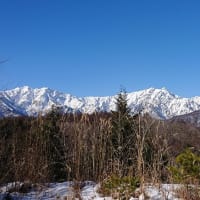
↓山頂からの景色は、雲海が広がっていた。

↑The view from the summit was a sea of clouds. It's like an island.
↓早速準備をして運用開始。
↑Prepare and start the radio operation.
先ずは、既に開局している山頂局を探して、FGL局、LCS局にお声がけ。
無事にS2Sをゲット。
その後、いつもの様に、14MHzから運用開始。
ZL1、W6、VK4からお声がけ頂く。DXのコンディションはそこそこだ。
その後、21MHz、7MHzとQSYしていく途中で、MJR局、MHA局ともS2S。
今日は山頂局、多いみたいだ。
7MHzでは、国内もそこそこ開けている感じ。
一通りCQを出し終わった後は、山頂移動局の開局待ち。
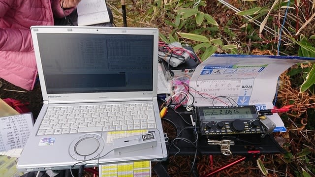
↓Antenna and the radio operation scenery.

↑アンテナと運用の様子
各局無事到着したようで、QWW局、DFO局、TXW局とS2S。
更にはツイッターでWMN局が飯綱山に登ると言うのを聞いていたので、お昼を食べながら更に到着待ち。
少し出発が遅れた様で、到着に時間が掛かっている様なので、到着したら、2mで呼んで貰う事にして、DJ-G7以外は撤収。
途中で、月山山頂局が2mで聞こえたので、X共々S2Sゲット。
そうこうしている内に、WMN局が山頂到着との事でコール有り。
取り敢えず、X共々2mでS2SQSO。
↓その後撤収を完了。

↑Completed withdrawal.
本日の結果 Today's result.
14MHz/CW 7-QSO 1-ZL1,1-W6,1-VK4 1-S2S 含む
18MHz/CW 1-QSO 1-S2S
21MHz/CW 4-QSO 2-ZL1 含む
7MHz/CW 19-QSO 7-S2S 含む
7MHz/SSB 1-QSO 1-S2S
144MHz/FM 4-QSO 2-S2S 含む
合計/Total 36-QSO 12-S2S 5-DX
今日は他の山頂局も多くS2Sは12-QSO/10座に上った。
山頂からの景色を一通り写真に収めて、下山開始。
↓高標山の直ぐ南東にある丸山

↑Mt.Maruyama is just southeast.
↓丸山から、朝は、小島の様に浮かんでいた小丸山にかけて。

↑From Mt.Maruyama to Mt.Komaruyama which floated in the sea of clouds like a small island in the morning.
↓山々はだいぶ紅葉に色づいてきている。
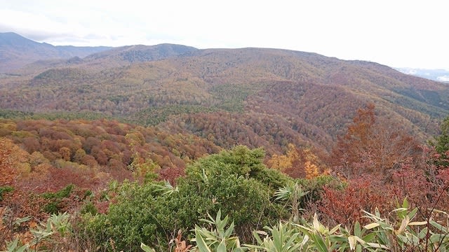
↑The mountains are getting more and more colored with autumn colors.
霜解けの路面が少し柔らかく、スリップしやすいので気を付けて下山。
↓下山途中で見つけた大きなベニテングダケ。(食べれません)

↑A large fly agaric found on the way down the mountain. Can not eat!
↓無事にゲートの車の所に到着。

↑Arrived safely at the car in front of the gate.
今日は全国的に天気が良く、沢山の山頂局が出ててS2Sが一杯稼げた。
本日もお相手頂いた各局様、どうも有難うございました。
Tnx for all stations who QSO with me !
2020.10.18 (UP 10/20)