On 24th Oct., I went to Takamatsuyama 1,670m JA/NN-101 for SOTA activation.This mountain is a minor, and the mountain trail is not clear, so I would like to climb it when the grass is dead in autumn, but what will happen?
↓Operation at the summit JA/NN-101.

ここは黒曜石ミュージアムの近くで、松沢林道から星糞峠経由のルートと作業用林道からのルートがある。(星糞とは黒曜石の事らしい、、)
どちらのルートもあまり登山道ははっきりしていないらしい。
There are two routes, but both routes are not clear.
なので今回は標高差の少ない作業用林道側から登る事にした。
↓県道155号線の高松山の南側の作業林道の入り口の近くに車を停める。

↑Park my car near the entrance to the forest road.
↓林道の入り口。大きな石があり車も停められない。MAP①

↑The entrance to the forest road. There is a big stone. MAP①
ピンテが見えるのでピンテの左の林道を登り始める。
↓林道は分岐が多いが、地図の点線に沿い山頂向きに真っすぐ登る。

↑There are many branches on the forest road, climb straight toward the summit along the dotted line on the map.
途中、地図の点線と異なり、下のMAPの②と③の所で道なりに曲がる。
↓MAP④地点。右前方の真っすぐ山頂に向かう細いルートを取った。

↑MAP④point. I took a narrow route to the top of the mountain straight ahead on the right.
帰りに気が付いたが左側は上に登る道と下に下る道が有った。
↓MAP⑤地点。まだ真っすぐも進めるが、進むと谷に突き当たりそう。

↑MAP⑤ point. Can still going straight. But go straight, hit a valley.
谷の最後は絶壁で登れない!なんて事になると困るので、左に折れて適当な所で尾根に取り付く事にした。
Turn left and attach to the ridge at a suitable place.
↓MAP⑥地点。少し低くなってる所から尾根に取り付く。

↑MAP⑥ point. Attach to the ridge from a slightly lower place.
↓低めの笹藪を掻き分けながら登る。踏み跡は殆ど無し。

↑Climb while squeezing through the low bamboo bush. There are no footprints.
↓しばらく林の中の笹藪を進む。

↑Go through the bamboo bush in the forest for a while.
↓木の種類が変わり、笹藪もカヤト藪に変わった。

↑The type of tree has changed, and the bamboo bush has also changed to Kayato bush.
↓林を抜けると、カヤトの斜面に出た。踏み跡は有る様な無い様な??

↑Through out the forest, I came out on the slope of Kayato.
↓振り返るとこんな感じ。山頂は近い

↑Looking back, it looks like this. The summit is near.
↓山頂到着。SOTAポイントは地図の山頂マークより少し西の三角点だ。

↑Arrived at the summit of SOTA point.
到着後、既に運用中のJNM局、BOK局と430/FMでS2Sをゲット。
↓その後急いで、無線機を準備する。

↑Prepare the radio system.
いつもの様に14MHzから開始。
Start at 14MHz as usual.
これまたいつものZL1局、VK4局、NW7局と交信。
21MHzにQSYすると、ZL1の2局に加えて、Wからのコールが多い。
弱いながらも、数局から呼ばれてプチパイル。
QSY to 21MHz. It's a petite pile up from NA.
極めつけは、ZL3AB局とS2S-QSO! DXとのS2Sは初めてだ。
The ultimate is S2S with ZL3AB! This is my first S2S with a DX.
7MHzに移る時にLCS局、FGL局とそれぞれS2S-QSO。
7MHzでは、これまたコンディションが良く、結構なパイル。
QSY 7MHz, the condex is also good as the pileup from domestic.
↓本日のアンテナ

↑Today's antenna
オンフレぴったりの周波数で呼んでくれる局は、聞き分けが出来ない状態。100Hz位周波数をずらせてくれると助かるんだが、、、
結局7MHzは0,2エリアを除く、1~9まで交信出来た。
最後に本日の2座目のBOK局とS2Sで終了。
本日の結果 Today's result
14MHz/CW 5-QSO 1-ZL1, 1-VK4, 1-W7, 1-S2S 含む
21MHz/CW 14-QSO 8-W, 2-ZL1, 1-S2S=ZL3 含む
7MHz/CW 32-QSO 1-S2S 含む
7MHz/SSB 1-QSO 1-S2S
430MHz/FM 2-QSO 2-S2S
合計 TOTAL 54-QSO
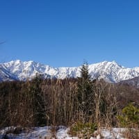
↓南東方向のJA/NN-031 蓼科山。

↑JA/NN-031 Mt.Tateshina in the southeast direction.
↓南方向。鷹山のスキー場。少し雲が出てきた。
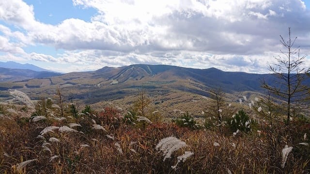
↑South direction. Takayama ski resort. A little cloud came out.
↓と言う事で、急いでお昼ご飯を食べて撤収。

↑Hurry up to eat lunch and withdraw.
↓カヤトの斜面を下る。南西方向にはJA/NN-089 鷲ヶ峰。

↑Go down the slope of Kayato. JA/NN-089 Washigamine over there.
薄い踏み跡をたどり下ると、登った時より少し西よりルートだ!
上りのルートを外れると心配なので、MAP⑧辺りで進路を東へ。
↓登りよりは多少踏み跡がある様な所をたどって降りる。

↑Follow a faint footprint and get off.
↓下に林道が見えてきた。

↑A forest road can be seen below.
↓MAP⑧の地点で林道と合流。

↑Join the forest road at map⑧ point.
↓合流して少し歩くとMAP④の地点。

↑After a short walk, arrived at the point of MAP④.
どうやら、登る時は④の地点で左上の林道に入って、MAPの赤い矢印の様な感じのルートが良かった様な気がする。来年はそっちに行ってみよう。
↓④からは、ひたすら真っ直ぐ下って、県道に出る。
↑From MAP④ point, go straight down to the prefectural road.
↓と言う事で、無事に下山完了。

↑The descent is completed safely.
↓本日のルート軌跡。

↑Today's route.
やはり、④で左上に行き⑨で上がらずもう少し先で尾根に取り付いて行けば、比較的踏み跡が有るルートだったのでは無いかと思う。
と言う事で道なき道を登る高松山。無事に上り下り出来て良かった。
もちろん、こんなマイナーな山、途中、誰にも会いませんでした。
Of course, I didn't meet anyone on the way to such a minor mountain.
本日もお相手頂いた各局様、どうも有難うございました。
Tnx for all stations who QSO with me !
2020.10.24 (UP 10/26)