On October 2nd, I went to Omeshidake 2,160m for SOTA activation.
↓Summit of Mt.Omeshi.

この日は、中秋の名月。
↓西の空に傾く月を眺めながら、暗い内に毛無峠へ向かった。

↑Depart home in the dark while watching the full moon.
↓毛無峠へ行く途中でニホンカモシカが車の前を横切った。
↑A Japanese serow crossed in front of the car.
1時間ほどで毛無峠へ到着。
↓今回は、良く晴れて長野側は雲海に成っている。

↑It's sunny and the Nagano side is a sea of clouds.
↓東の空からは、毛無山の途中から朝日が昇って来た。

↑From the east, the sun rose from the side of Mt. Kenashi.
↓峠は風が強く、非常に寒い。ダウンにカッパまで着て登り始めた。

↑The entrance is windy and cold.
Start climbing wearing a down jacket and rainwear.
先ずはすぐそばの毛無山に登る。
↓初めのうちは登山道がはっきりしない斜面を登っていく。

↑Climb a mountain trail that is not clear.
↓斜面を上がっていくと右手方向に登山道の踏み跡が見えて来る。

↑After climbing a little, see a mountain trail on my right side.
↓標高差概ね110mを約20分で登り毛無山の山頂に到着。

↑Arrived at the summit of Mt. Kenashi at 1930m in 20 minutes.
↓毛無山山頂を通過し、一旦50m程下って登り返す緩い稜線を進む。

↑pass the summit, down about 50m and climb again.
And follow the gentle ridgeline.
↓この辺りは気持ちの良い稜線歩きである。

↑This area is a pleasant ridgeline walk.
↓登山口から1時間ほど歩くと、道は樹林帯に入り、木の間の急登を進む。

↑After walking for about an hour, entered the forest belt.
Follow the steep road between the trees.
↓木のトンネルみたいなのを抜けると、樹林帯から抜ける。

↑Walked for a while, and after passing through the tunnel of trees, I passed through the forest belt.
↓抜けると少し緩やかな道になった。

↑It became a gentle climbing road.
↓一瞬行き止まりの様に見えたが、木の間を抜けると道は続いている。

↑It looked like a dead end, but when I passed through the trees, the road continued.
↓山頂到着。ここ迄2時間6分程かかった。

↑Arrived at the summit. It took about 2 hours.
↓早速シャックを開設して、先ずは四国の石鎚山に登るAWE局をコール。

↑Prepare a shack and call AWE-san who is climbing Mt. Ishizuchi in Shikoku.
XYL共々無事にS2Sをゲット。7MHzのコンディションはなかなか良い。
Get S2S with XYL. 7MHz CONDX is good.
↓いつもの様に14MHzに移って、CQ開始。

↑Next, go to 14MHz and start CQ.
DXのコンディションはもう一つか、DX局はUSA局が1局のみ。
DX CONDX is not good. Only one QSO with USA station.
途中でXYLから、又電源が入らないとクレーム。
After a while, XYL said her FT-817 couldn't turn on.
14MHzの区切りがついた所で、電源を調べる。
どうも接触が良くない。手元にあったワニ口ケーブルをカットして、接触していない端子に挟んで、強制的につないで無事に動くようになる。

↑Examining the battery, it seems bad contact. Connect with alligator clip cable directry.
HFに戻るとMHA局のSPOTが上がったので、7MHzで2局目のS2Sゲット。
この後、21に上がるが、1局のみ。
今度は10MHzでTXW局のSPOTを発見。コールして3局目のS2Sゲット。
この後7MHzに降りる。途中でJクラに載った様で、プチパイル状態。
7MHzで1時間ほど呼ばれ続け、やっと途切れた所で終了。
丁度お昼なので、コンビニおにぎりを出し、看板の前でパチリ。

↑Lunch break.
写真を撮ってから昼食。
その後2mSSBで出ていた御嶽山のHRC局とQSOして撤収となった。
本日の結果
14MHz/CW 5-QSO USA-1局
21MHz/CW 1-QSO
10MHz/CW 1-QSO 1-S2S
7MHz/CW 29-QSO 1-S2S
7MHz/SSB 1-QSO 1-S2S
144MHz/SSB 1-QSO 1-S2S
合計 38-QSO
↓本日のアンテナと周囲の様子

↑Today's antenna and shack.
↓撤収して下山する頃には、山頂は少しガスに包まれてきた。

↑Gas came out when I went down the mountain.
上手い具合に日陰に成って、涼しく下山開始。
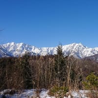
↓樹林帯を抜けると、ガスは晴れ、毛無山までの稜線が良く見える。

↑The ridgeline leading to Mt. Kenashi. Behind them are Hafudake and Donabeyama.
途中毛無山で、ヤマランのポイントの為にXYLがQSOしようとしたが、ハンディは2台とも電池切れ。
毛無山山頂で少し時間を食ったが、下りは1時間55分で無事下山。

↑Descent completed.
御飯岳山頂の眺望が無かったのが残念だった。
でも気持ちのいい稜線歩きは、なかなか楽しかった。
本日もお相手頂いた各局様、どうも有難うございました。
Tnx for all stations who QSO with me !
2020.10.02 (10/5 UP)