パエ-リャ

木製カトラリ-

スマホとグ-グルマップに関わる忘備録 (3)

2016-12-18 10:23:08 | Weblog

富士通のMO1(アンドロイド)で主要に使うことができるマップアプリは、日本語版では現在2種類稼働することができる。一つは最初からMO1に組み込まれているグ-グルマップの簡易版で、Gマップと便宜上呼ぶことにする。もう一つはストア-から無料ダウンロ-ドしたマップアプリで、「マイマップ」との表示があるので、Mマップと呼ぶことにする。

以下は、それぞれのマップアプリで表示がどのように異なるかを示す忘備録になる。いずれの場合もスマホで直接地図を編集するのではなく、PCで既に編集した地図を単純にスマホで参照したいという、切実な願望が背景にある。

なので、最初に、PCで作成した地図に名前を付けて 保存する。以下がそれだ。


このPCでのグ-グル地図では高雄市内の地点から目的地、里港、までのル-トの簡易表示と、バス停の目印が記入されているのがわかる。

以下はMO1標準装備のGマップ(単にマップと表示されているアプリ)での表示内容になる。


これは、初期メニュ-のマイプレイスから、「地図」項目に保存されているものを単純に開いた場面で、ル-トどころか、目印も表示されていないのがわかる。

マイプレイスには他に、「ラベル付き」や「保存済み」などの項目がある。 この画面の一番右端にあるのが「地図」のボタンになる。「ラベル付き」や「保存済み」などの項目の話は別途になるが、「地図」には何も必要な情報が載らないことが理解できる。

次に(別途ダウンロ-ドしたアンドロイド地図アプリで)「マイマップ」と表示されているものを

起動してみると、次のような初期表示になる。     

このうちの、ハイライトされた「自作の地図」を開いてみると以下のような画像になる。

          つまり、目印は消滅しているが、簡易ル-トだけは生き残っているので、これはこれとして使い道はある。ただ、問題は、このMマップアプリは既に存在するマイマップのみを上記のように不完全に表示するだけで、Gマップのメニュ-にあるような「ラベル付き」や「保存済み」などの地図の表示が不可能なことだ。

逆に、Gマップでは「ラベル付き」や「保存済み」などの地図の表示は可能なのに、PCで編集したマイマップの表示が出来ないわけで、となると、当然使い分けを考えることになる。つまり、目印はGマップ、簡易ル-ト表示はMマップというように。非常に馬鹿々々しい話だが。


スマホとグ-グルマップに関わる忘備録 (2)

2016-12-17 09:13:28 | Weblog

この忘備録はPCと富士通MO1との間のグ-グルマップの受け渡しに関わる実際的な解決策を記述している。

根本的な理由は、PCで編集したGマップをアンドロイドで参照しても、使える目印機能が極めて限定的なことだ。

具体的には、アンドロイドでもレイヤ-は参照できるし、ON/OFFも機能するが、実際にはレイヤ-に載っているはずの地点目印が表示されない。3種類ほどのアンドロイドアプリを試したが、どうにもならない。あるアンドロイドアプリは、初期画面ではPCでつけた目印がしっかりと表示されているが、ズ-ムして付近の詳細を見ようとすると、目印そのものが動いてしまうので、使いものには全くならない。

唯一、何とかなるのが、当該地図にPCで名前をつけて保存して、アンドロイドで参照することだ。アンドロイドの小さな画面で編集するのは絶対に避けたいし、本来、必要ないはずだからだ。以下が手順になる。

1. PCでの編集作業

PCで単純にGマップを開いて(つまりマイマップを新たに作成するのでははなく)、任意の場所で右クリすると小さなポップアップが出るので、「この場所について」を左クリすると、番地名か座標を選べるようになる。ここで、例えば座標を左クリすると、大きなポップアップが画面の左側に出る。この時に地図上では指定した地点にビックリマークのみが現れる。ここで、大きなポップアップの青星の「保存」を選ぶと、ビックリマークの根元に金星が現れる。

この時に、同じ大きなポップアップの「ラベルを追加」を押すと、同じ大きなポップアップの、それまで青かった星が金星に変わり、同時にラベル書き込み用のボックスが出現する。その中に任意のラベル名を書き込むと、書き込んだボックスのすぐ下の、薄い旗マ-クの右側に今入力した名前と、更に、そのすぐ右側に薄い文字で「ラベルの追加」と表示が出る。(この時に同じ大きなポップアップの一番下にも濃い旗マ-クと、濃い文字の「ラベルの追加」の表示があるが、それは無視する)

薄い文字の「ラベルの追加」を選ぶと、PC画面の右下に「ラベル名を追加しました」と数秒間の表示があり、同じ大きなポップアップの座標のすぐ上にラベル名が現れる。(この時点では、地図上のビックリマ-クと金星の場所には、ラベル名は追加表示されてはいない)

以上で命名と保存は完了する。以下はアンドロイドで参照する場合の操作方法だ。

2. アンドロイドでの参照手順


単純にアンドロイドのGマップを立ち上げて、マイプレイスを選んで、3本線メニュ-を開くと、一番左は「ラベル付き」なので、その一番下にラベル名が表示されているのがわかる。このラベル名は、そのラインの右側のX点マ-クで、即、削除できる状態になっている。


次に、「保存済み」を見てみると、左側から、金星、座標、3点マ-ク(これは、実際には削除ボタンの機能しか持たない)が一列に並んで見えるので、ここでも保存済みの金星を即、削除できることがわかる。

3. PCが使える場合の参照手順 (ラベル付き、と 保存済みのみに限定した操作方法)

この時点でのPCでの確認操作は初期メニュ-(3本線メニュ-)から「ラベル付き」の項目を選んで、目的地のラベル名を押すと、ビックリマークと金星の両方で目的の場所が地図上で確認できるのがわかる。この時にはその場所のラベル名は地図上の金星のそばには見えないが、大きなポップアップの保存済み金星をおすと、その金星は青くなり、地図上の金星が消えて、代わりにその場所のラベル名が同じ場所に表示されるようになる。もう一度青い星を押すと、元に戻る仕組みだ。

「ラベル付き」の場合は、中身は明快にわかるが、「保存済み」には、もし座標で最初に保存してある場合には、座標のみのリストしか見えないので実際には使えない。但し、特定の座標で保存して、更にラベル名も与えてある場合には、その座標を開いてみると、左側の大ポップアップメニュ-の中にラベル名も併記される。

ただ、実際にはPCが使えるなら、レイヤ-も、その中身も参照できるわけなので、単純にマイプレイスからマイマップに進んで構わない。後は地図名のリストが出るので、なんとでもなる。


スマホとグ-グルマップに関わる忘備録 (1)

2016-12-17 08:12:14 | Weblog

外国、特にフィリピンやマレ-シア、インドネシアなどに滞在しているとグ-グルマップが利用できない場合がある。ただ、その場合でも、SIM経由でのマップの参照が出来ない場合は、極稀で、今までにフィリピン中部地方の島で1回だけ経験したことがある。

問題は、ノ-トブックを持ち込んでいる場合、普通、ノ-トにはSIMの取り換えどころか、SIMそのものが付いていないので、WIFI経由でしかグ-グルマップを参照できない。最大の、然も、頻繁に起きる問題はそれが原因で発生する。

つまり、ホテルを予約する時に、仮に各部屋でWIFIが無料で使えます、などと表示されていても、5割の確率で使えないからだ。この直近の1年でも、30軒以上のホテルに泊まり歩いた経験から言えることだ。考えられる理由は、そのホテルに届いている電波がそもそも微弱で不安定か、あるいは館内のWIFI中継器の不具合だ。

となると、現地SIMを装着した自分のスマホでノ-トパソコンに対してテザリングするしかないわけだが、そんな場合、元々の電波が不安定なら、必ず速度が遅いので役に立たない。然も日本国内と同じような利用制限は必ずあるわけだし、のんびりと地図を眺めて、色々考えるわけにもいかない。

なので、根本的な解決策はSIMが付いているノ-トパソコンを買えば良いわけだが、そこにも問題がいくつかある。

1. 仮にSIMが付いていてもノ-トパソコンは持ち運びしたくない。重いし、大きいし、自分のように、ホテルを転々とする場合、ス-ツケ-スなどでなく、バックパック一つで移動するので困る。

2. そもそも、SIM付きのノ-トパソコンは稀だし、仮にあったとしても中国製や韓国製なら買う気はない。

3. そうなると、タブレットになるわけだが、中国製、韓国製は絶対に買わない。この観点から、タブレットを調べてみて、フィリピン製の7インチが最適で購入した。フィリピンは国産品が外国産よりも売れている、賞賛に値する珍しい国だ。部品は日本製が多いので、問題はない。アウトやインのカメラもついているし、何より、めちゃくちゃ軽いのが素晴らしいと思う。

チェリ-モバイルブランドで販売されている最高級の機種は、まず、SIMを2個着脱できる。WIFIでの利用も勿論できる。しかも電話としても機能する優れものだ。しかも、最上位機種でも4900ペソ程度(おおよそ1万円強)で、免税ならもっと安いかもしれないので、極めて安くて便利だ。

早い話、とても大きな dual SIM のスマホだが、SIM1個しか使えない、例えば富士通のMO1などでは、国内用のSIMが無くならないようにとても気を使うが、それも必要なくなった。海外旅行用に特化した使い方が出来るので、もうこれなしには海外には行けない。

でも、SIMでも解決できないのは、電波が完全に届かない場合だ。例えばボルネオ北部のキナバル山では登山中に頻繁に電波が途絶えてしまった。更に、ボルネオ各地にある自然保護地域でも起きる現象だ。

この場合は、OFFLINEの地図を利用するしかない。勿論、グ-グルマップの必要な部分だけ切り取って、OFFLINE的に使うことは出来るが、それは究極的な解決策ではない。

では、どうするかというと、タブレットにOFFLINE地図をあらかじめダウンロ-ドしておくことだ。色々あるが、自分はアメリカでよく使われているのを利用している。外国での使い勝手が良いからだ。

で、以上は忘備録の頭の部分で、次の記事で実際的な本題に入る。


Fishing in the Philippines - Surigao/ Siargao and further south (1)

2016-11-27 08:51:06 | Weblog

A picture is emerging. Take a look at the following Google clickable map that I have been making. This is being added to and improved constantly.

https://goo.gl/B47huj

This region is greatly influenced by the winds and currents coming uninterrupted from the Pacific. Coast lines may be that much cleaner, as a result...

Anyway, the grand picture seen by me at the moment is this.


There is a clear corridor of journey for foreign visitors, west of Surigao. We could use part of this corridor to get to Surigao, clockwise or anti-clockwise.

Alternatively, you could make it into a complete set of articulated trips and be happy with it. If I haphazard a guess Surigao is a very large town and is probably worth spending a day or two there for civilised eateries.

That apart, we see blocks of areas of interest, potentially 3 blocks of them. B1 is Surigao centred. B2 is Siargao centred. B3 is something more off the beaten tracks, perhaps and more interesting about B3 is the fact that although it is part of Surigao del Sur it is already reachable form Davao (or Tagum).

Zamboanga down to General Santos line is now too dangerous, due to Islamic extremists being rampant there. Manila-Davao air route should be OK unless you walk into downtown Davao near the river and People's Park area there and instead go straight from Davao International Airport to regions.

These are the basis upon which I contemplate on my next fishing trips in the Philippines almost everyday I am bathing in the infinity onsen pool at my gym.

I am mindful of the knowledge that the bays north of Mindanao are rich in yellow fins and other tuna spices. Perhaps, I should go for it? In January 2017?, before my planned Taiwan (south) visit in February and my March visit in Palawan north?

It all remains to be seen...


Fishing in the Philippines - You Tube videos only

2016-11-25 08:40:32 | Weblog

What follows contains movies.

https://goo.gl/UHDGB0

If locations are known they are placed in their vicinity. If not they are clustered together just south of Taiwan.

River/lake fishing and netting are excluded.


Fishing trips in the Philippines - Samar (3)

2016-11-24 13:54:29 | Weblog

We now have a much better understanding of this region, generally known as western Samar and what I call "Inland sea of Samar", if not much in terms of information on fishing. To go any further we will have to visit this place and talk to people there.

Inland sea of Samal (coined):  https://goo.gl/DRSx4V 

So, what do we know now? There are many, but the most important is the overwhelming importance of Cebu International Airport on Mactan and the ferry port just across from it on the island of Cebu.

For your information we noted earlier that the port of Cebu is best reached from Mactan by a very short (20 minutes) ferry. Taxi ride will be PHP 400 and takes much longer in time.


To get to western Samar the key place is Ormoc and to get to Surigao and beyond it is Maasin. Cebu is that important and is the corner stone of everything in the Visayas and south. We will be looking at Surigao and surrouding areas separately.

Let us take a closer look at western Samar, as follows.


There are three blocks of interest. B1 and B2 are connected by bangka boat, apparently, but there was very little I could discover about this short crossing.

Whether or not B1 and B2 are connectable about the only realistic way of getting to them is via Omroc and then by bus and ferry. Block B3 can only be reached from Catbalogan by ferry and by land from Ormoc.

Here, we note that the land sections 1,2, and 3 by bus are all more or less 3 hours and that there is no ferry between B1 and B3.

We also note that block B2 is best reached from Calbayog and there still remains the question of getting there how.

From my experience of Cebu-Dumaguete by Ocean Jet (4 hours plus) my guess is that the route Cebu-Ormoc will be very similar in time and if you add the bus ride from Ormoc it is certain that you will have to stay overnight in Tacloban.

From Tacloban to Calbayog will be another day by bus, so there is always this temptation of going to Naval in Biliran by bus from Ormoc and keep our fingers crossed for the ferry from Naval to block B2.

While I throughly enjoyed my 3 hour bus ride between Davao and General Santos in Mindanao the mere thought of 6-7 hour bus ride from Tacloban to Calbayog is daunting.

Actually, I have since found the following:  https://goo.gl/0ToQY5

This article by, presumably a retired American, I think, is very, very good. I only had a very quick look, but he does mention Maripipi - Almagro - Calbayog line of movement by boat in some concrete and plausible manner. He also mentions land route options with costs.

See also: https://goo.gl/zR54HO

Anyway, the food for further thoughts is all here. We will now be looking at Surigao/Siargao areas in the next few artcles.


Fishing trips in the Philippines - Samar (2)

2016-11-15 11:03:02 | Weblog

https://goo.gl/5eaEDr : Western Samar in general

https://goo.gl/cJy7MK :   Catbalogan in general

https://goo.gl/03pdYZ :   12 things to do in Catbalongan

Above 3 shortened URLs carry rather mundane information, the 3rd in particular. Who wants to do caving? I do not. On the other hand you cannot always get information on fishing trips and island hoppings.

What you really need to do, therefore, is to form an impression on this vast area from various sources and at the end of the day conduct your own information gathering, by actually visiting the area and by talking to people there.

Following clickable Google map is meant for assisting you in that direction.

Inland sea of Samal (coined):  https://goo.gl/DRSx4V (now available for universal viewiing)

This is still very much under construction and is expanding day by day. Clickable sea routes will generally give you information on boats, either ferry or bangka boats.

Markers on each island are meant to give you a lot more information, sometimes even you tube movies. Positions and colours of the marker does not mean much, except that they are about the island they are placed on.

Yellow coloured inverted tear drops contain You tube movies and those in chocolateow contain still pictures.

Following map, actually a world map, is very, very useful to find minor ferry routes in the Philippines. I came across this by accident.

https://goo.gl/fS6w0p 

(World map, btu very details and useful in finding minor ferry routes)

I have been particularly impressed by the articles on the island of Biliran, by a Pilipina motor bike rider. I think they are superb. The same girl also contributed two articles on her experience with the island of Bohol, as follows. 

Articles on Bohol motorbike tour:  https://goo.gl/01iYPc 

I myself did my own motor bike tour of Bohol in April 2016 and yet the area covered by her is a lot more extensive, beautifully narrated.

You will be able to find her other articles within the island markers.


Fishing trips in the Philippines - Samar (1)

2016-11-11 12:47:26 | Weblog

1. Manila based routes:  https://goo.gl/iiS1jJ

2. Non Cebu/non Manila based routes (1):  https://goo.gl/GCZPGh

3. Non Cebu/non Manila based routes (2): https://goo.gl/9f0X2a

4. Cebu based routes (1): https://goo.gl/gxHE2f

5. Cebu based routes (2):  https://goo.gl/tJIXZm

6. Cebu based routes (3): https://goo.gl/dMOlQW

We need these maps. We need them to understand and make sense of island denser regions of the Phyls from foreigners' point of view.

Let us first take a look at the area surrounded by the islands of Masbate, Leyte, and Samar. Let us also turn on every single layer on our clickable maps.

Turning on all the ferry routes does not mean we want sea travels only. We initially want to see what kind of pictures we get if we do that. We also want to see traffic density because at the end of the day we want to go to seafood restaurants. They are more likely to be found at the ends of heavy traffic lines.


This is the area we are potentially interested in. Island denser sub-regions are in three squares. At this scale of the map noticeable towns are found only on the island of Samar.

We expected, naturally, that there be a fairly large town where Samar is ferry linked to Luzon. There is none. It means that the area in the topmost square will drop out.

We are not interested in towns in the outer fringes of these islands as it will mean bus ride of consirable distances. We also note that if there is a system of island hopping with fishing then Calbayog and Catbalogan must be the key ports.

Now, with that in mind and if you turn on the Manila based map you will find that there is no ferry service from Manila to these towns, which is surprising. And, there are only two ferry operators looking after these two ports and they all operate out of Cebu.

(Cebu based 2 and 3)

Take a look at the following map. 


This map came about because my gut feeling was that in order to reach this region one easiest way was to fly from Manila to Calbayog. There is an airport there, but flights are few and far between and are rather expensive.

You can plan better if you fly to Cebu instead, but there still remains the question of what next then from there. Remember we are interested in the small islands and seas around them for our fishing and island hopping within this polygon in red.

One way seems to be the trip by bus from Cebu to Bogo, and there is a clear indication on this Google map that Bogo and Cataingan on Masbate are connected by ferry. So, if we can cross over to Calbayog from Masbate then we can start thinking about our fishing expedition there.

Unfortunately, there is no ferry service from Masbate to Samar, which is surprising. So, in oder to get to Samar we will have to take a ferry direct from Cebu to Calbayog or Catbalogan. (See Cebu based 2 and 3)

By the way, the easiest way to handle these clickablle maps is to start from the bottom layer and work upward. That way you will have a better view, Start by having all layers turned off.

From my seperatre searches the bus ride between Calbayog, Catbalogan, Tacloban, and Ormoc is just under three hours each. Tacloban is where Samar is bridge connected to Leyte.

So, we now have a grand picture of trips for this region. Fly Cebu and ferry to Samar. Do your fishing and island hopping down Calbayog/Catbalogan and somehow reach Ormoc by bus and ferry back to Cebu, and fly out to Tokyo from there.

In the next article we will be looking at what actually may be done in this region.


Philippine ferries, routes, maps, island hoppings 2016

2016-11-09 07:57:59 | Weblog

To my mind there are only two countries in the world, Indonesia and the Phillipines, which we can truely describe as insland nations. Japan is not worth being called one. 

For touristic travels in these two countries you need user friendly route maps. I have uploaded clickable maps for Indonesia. They are hadly user friendly because the source information is all in Indonesian.

With the Phillipines it is somewhat easier as information is available in English.

Following Google maps for the Phillipines are all clickable. Maps are constantly updated and added to with information only useful to foreigners (repeat, only foreigners) wishing to spend time in the Phillipines. URLs have been shortened.

1. Manila based routes:  https://goo.gl/iiS1jJ

2. Non Cebu/non Manila based routes (1):  https://goo.gl/GCZPGh

3. Non Cebu/non Manila based routes (2): https://goo.gl/9f0X2a

4. Cebu based routes (1): https://goo.gl/gxHE2f

5. Cebu based routes (2):  https://goo.gl/tJIXZm

6. Cebu based routes (3): https://goo.gl/dMOlQW

Routes and ports are clickable and in many cases further information can be found by clicking on the lines. Alternatvely, you can do so with the legend.

We note that the sheer number of Cebu based routes is indicative of the fact the Cebu is the hub of all places for tourists wishing to spend time in Visayas and areas further south in the Phillipines.

You could start out from metro Manila to places, of course, but I would not advise it primarily because it takes a lot of time, generaly. The only exception may be the trip down to the northern half of Palawan.

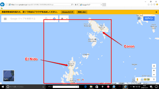
Even that can be replaced by air. There are regular daily flights from Manila to Coron and El Nido and once you are there there are now regular fast ferry connections between El Nido and Coron, something like 3.5 hours one way.

The slower Bangka (?) boats take longer, 8 hours, but their operations are stable.

By looking at these route maps and from reading a number of Phyls related blogs it daunts on me that the islands of Samar (bigger Samar) and Leyte are rarely visited by foreigners, much less so by the Japanese.

It may be because of the lingering memory of the largest air/sea battle in history fought between Japan and US/Australia in these waters. I personally think that it is about time we went to these islands in large numbers. That will help local economy of the region.

Ferry companies come and go. I noticed that while collecting information. One of the Lonely Planet's interest was the two international sea routes, Zamboanga (Mindanao)-Sandakan (Northern Borneo, Malaysia) and General Santos (Mindanao)-Manado (Menado) (Northern Surawesi, Indonesia).

I did go to Gen San in July this year to check out on this route. It is closed. With Zamboanga-Sandakan it is my conclusion that this is also closed. These two routes used to be operated by the same company, but it seems to me that they have shrank their operations considerably since.

A few additional and sporadic/unrelated comments are:

1. Dumaguete-Tagbilaran by Ocean Jet is alive. I took that ferry myself in July to catch my flight from Cebu back to Tokyo. Actually, it is Dumaguete-Cebu as I did not need to change boats on the way back.

2. The El Nido-Coron is now OK. The ferry company there, Montenegro, stopped their fast ferry service a few years ago, but they are back in with 3.5 hours one way.

3. Metro Manila-Corregidor trip, one hour one way, is good. It is a flower island littered with legacies of the War. It is very much like Capri minus the furnicular.

4. Puerto Princesa may be too risky at the moment, so are Zamboanga and even General Santos. Davao should be OK, unless you walk into down town area near the river there.

Finally, an extremely useful world map is added here.

https://goo.gl/fS6w0p

This map is actually useful in filling the gaps which my own maps cannot carry.


Tourist places in the Philippines - personal overview (1)

2016-11-08 13:30:11 | Weblog

I have no personal interest in the island of Luzon, except the old part of Manila called "Intra Mullos" and the small island of Corregidor at the mouth of Manila Bay.

I am not interested in the northern half of the Phillipines, either. It rained virtually everyday and all day while I was last in Manila for a week or so.

On the other hand islands much further north, almost bordering with Taiwan, they look very interesting. I noted with pleasure that up there you can have coconut crabs, surprising cheaply.

Tropical regions are often associated with beaches. However, one other thing I am not interested in is beaches to lay your back on. It is the tropical vegetation and sea creatures I am most interested in and that is closely related to small islands.

Ideally, any one of these islands should be entertaining a few King Kongs hiding in the mountain area. These islands should also have streams/falls and large ponds if not lakes.

These are the criteria and the basis upon which I am going to form my impressions on certain regions in the Phillipines.

There are blog articles about places. They are usually "I visited such and such places and they were like so and so" type descritions. I will go further than that, by first form ing an impression, then actually visiting those places and finally evaluating the visits for general readership.

Now, the Phyls itself is an island country. That is why all these clickable maps were produced. However, within the Phyls there are island denser regions with many small islands.

Typical example is the northern Palawan, between el Nido and Coron.


Southern half of Palawan, particularly south of Puerto Princesa, at the moment, will be too risky due to the insurgence of Islamic militants.

About the area enclosed in the square in red I have read extensively and there is no need for predictive formation of impression. I will simply go there within the next few months, if not few weeks.

If you cast your eyes further south then you have a similar chain of islands between Mindanao and northern Borneo.


Unfortunately, although location/climate-wise by far the most interesting of all island denser regions, this chain of islands is infested with Islamic militants. It is a no-go area. So, you must look further north.

The first thing you notice is a number of small islands around Bohol and between Bohol and Cebu, in particular. However, these are not islands. They are simple flats. There is no elevation to speak of. In fact, I know this area very well by now as recent result of going up and down there many times .


So, if you take a step back and look wider you will notice that there are a few other regions. One is the sea surrouned by the islands of Masbate/ Samar/Layte. Other areas are around Surigao and Siargao.

It is these regions that there is not much informtion about , made available, yet, by foreing tourists. In the articles to follow I will be looking at issues that must be understood before visiting these regions.