パエ-リャ

木製カトラリ-

パエ-リャの旅行記 - 台湾北部

2016-07-24 05:11:04 | Weblog

非ガイドブック的なメモにしよう。

台湾は驚くほど小さい。そして台北も驚くほど小さいし、台北より北の部分も通常の観光目的の範囲以内では驚くほど小さい。確か、今では桃園空港と呼ばれ、以前は蒋介石空港と呼ばれた空港でなく、台北市内の松山空港に降りたつと良く解る。

松山空港自体も小さい。女満別ほど小さくはないが、山口宇部みたいなものだと思う。で、空港を出ると否応なしに台北101が見える。101は台北市の南東ギリギリの所にあるが、空港から歩けば2時間はかからないだろう。

台北の問題は、こう言う事だ。東京でデズニ-ランドに行きたければ電車で行けばよい。でも、松山空港から目と鼻の先にある故宮博物館には所謂「最寄りの駅」は存在しない。少なくとも、東京的な意味では。

台北、いや台湾を代表する場所なのにバスかタクシ-になる。或は、歩いて行く事も考えられるが、ナントカして欲しいものだ。然も、ガイドブックには帰りのタクシ-でぼられる事があると書いてある。東京で言えば上野の動物園に行くのにバスでしか行けない様なものだ。

で、台北観光なら

九分は誰でも行くだろう。東京近郊で比較すると東京駅から鎌倉に行くと思えばよい。内容的にではなく、東京駅を起点とした時間の感覚だ。そして、九分にも勿論最寄駅はない。ないので、交通手段としては:

1. 台北市内から直通バス
2. 乗合いタクシ-
3. 鉄道とロ-カルバス

しかない。自分が参照していたガイドブックでは台北駅のすぐ隣にある大きなバス駅からではなく、市内のありふれたバス停から(そのために探すのに苦労する)直通バスが出る事になっていて、不思議だったが、そこに行ってみると必然的に(?)乗合いタクシ-に誘惑されてしまう。

運転手が勧誘のため大きな紙に値段と行き先を書いて待っているからだ。明らかに台湾の観光客も同乗したので悪いレ-トだとは思わなかったが(500元、日本円で約2千円、片道約1時間の行程)、帰りの台北までのタクシ-は1000元を要求するので止めた方がよい。

で、帰りはどうしたかと言うと、と言うか台北行き直通バスが全然来ないので仕方なく、頻繁に来る「ル-ファン」という鉄道の駅まで行くバス(10分程度)に乗って、鉄道で帰って来た。バスと鉄道の合計で80元程度だ。ガイドブックはバスで往復出来るような事を言うが、肝心のバスは待っていても来ないと思った方が良い。

ガイドブックはウソは言わないがバスの時刻表ではない。

なので、九分は、行きはバス、帰りはロ-カルバスと電車の組み合わせが現実的だと思っている。電車は頻繁にあるし、ロ-カルバスもどんどん来るので便利だ。

九分で気を付けなければいけないのは、グ-グルマップとガイドブックでは地図の方向が異なることだ。九分は急な斜面に街がへばりついているので、バス停は上の方と、下の方にあるだけだ。ガイドブックでは、だから下のバス停が地図の下側になっているが、それは南ではないので、混乱する場合がある。

ガイドブックの地図の方が感覚的には優れているだろう。何故なら誰でも最後は有名な街の真ん中の急坂を下りたくなるし、坂を降り切ると、そこが下のバス停になっているからだ。

結局、台北の観光は市内と九分と故宮博物館だろう、普通は・・・九分のそばには十分とか五分とかあるが、それらも基本的にはル-ファン駅が起点になる。

試しに台湾新幹線で新竹まで往復してみた。片道30分、往復で300元ほどで驚くほど安い。新竹駅はとても近代的だ。恐らく台湾高鉄の他の駅もそうだろう。上手く表現できないが、鉄腕アトムに出てきそうな感じだ。

で、途中で思ったのは、若し桃園空港についたら、以前みたいにバスやタクシ-だけでなく、新幹線で台北に移動できるかどうかだ。以前タクシ-で台北まで移動した時には、片道1時間ほどかかった記憶がある。

台湾北部に関しては、あと「基隆」と「金山」が考えられる。金山は台北の北東にある漁港で、基隆からロ-カルバスで30分程海岸沿いを北上すると到着するが、普通の観光客は金山までは行かないだろう。

基隆は見た感じは横須賀港程の大きさだ。町自体は大きい。ものすごく活気もある。然も台北からの電車の終着駅なので間違いもない。台北から1時間もかからないだろう。

基隆から金山への海沿いの風景は熱海から小田原と言う感じで、バスで1時間はかからない。金山は変な街だ。そこらじゅうに鴨を食べさせる店がある。でも、生きた鴨は一度も見かけなかった。その代わりに観光客がゾロゾロと歩いているメ-ンストリ-トに平行した通りで、お婆さんが沢山の雀に餌をやっていた。

それ自体は、どうと言う事はないのだが、雀がハトみたいに行動していたのにはショックを受けた。雀は逃げるものとしか思っていなかったためだ。兎に角、逃げない、30cmまで近ずいても全然逃げない。

それは兎も角、金山への簡単な移動手段は往復とも台北から直通バスが良いだろう。片道1時間半ほどだ、確か。地図で見るとバスなら山道をクネクネと行く印象を受けるので、電車とバスがよいと思い、行きはそのようにしたが、帰りはメ-ンストリ-トにあるマクドナルドの真ん前のバス停から台北行きの直通バスがあるので便利だ。コ-ヒ-を飲みながらゆっくりとバスの到着を待つ事が出来るので安心できる。

で、台北に向かうバスは山道などは走らないで、途中まで海沿いに基隆方面に向かい、大きなリゾ-トホテルがある所で、内陸に向かい、ほとんど高速道路で台北に到着する。途中の光景は、一言で言えばアルファトマムとしか言いようがない。20階建て程の高層住宅がなだらかな丘陵地に点在しているからだ。夜間は相当荒涼とした風景になるだろう。

理由は全然不明だが、台北近郊には一戸建ての住宅が皆無だ。以前、仕事で蒋介石空港からの往復のタクシ-から観察した時も、今回電車やバスで移動した時も一戸建ての住宅は見なかった。一軒くらいはあってもよさそうなものだが、文字通り一軒も見なかった。だからアルファトマム的になってしまうのだと思う。

台湾は乾草の匂いがする素晴らしい国だ。毎月訪れてもいい程だ。繰り返しになるが、台北はとても小さい。首都ではあるが東京とは比較にならないほど小さいし、通りが凸凹している。KLなら突然のスコ-ルで靴が濡れないよう凸の部分に逃げる訳だが、台北にスコ-ルが来るとは思えない。

地下街は台北駅の地下にしかないだろう。地下街と言っても、とても小さくて、然も場所によっては通路がとても狭くてドンキみたいだ。地震が来たら怖いと思った。

台北101は、たまたま近くに台湾人の友人の事務所があるので通りかかって覗いたが、B1のレストランはひたすら巨大で昼時はとてもゆっくりできる場所ではないと思った。でも、さすがに近辺の道路は平らで、凸凹は見られない。鳩は見かけなかった。アグネスチャンが言っていたように、ウロウロしていると捕まって食べられてしまうのかもしれない。

地下鉄は立派だ。そして、とても綺麗で路線図も簡単で解りやすいので、歩き疲れたらドンドン利用するべきだろう。安いし。そうそう、言い忘れた事、コンビニは何処にでもあって、必ずトイレが利用出来る、然も中で簡単な食事が出来るようになっているので超便利だ。オニギリも売っているし、日本のコンビニとの違いはない。

最近は自転車を貸してくれるようになったらしい。以上、台北編


DIYア-ク溶接のコツ

2016-07-24 05:09:22 | Weblog

ホ-ムセンタ-、 溶接機、 溶接棒、家庭用溶接機

家庭用の100ボルト溶接機は安い。上手く使えれば、ガ-デニング関連での作業にとても役に立つ。典型的なシステムとしては、このような感じになる。ア-ス線とア-ス棒は見えていない。


手前左のはさみは溶接棒を挟むための一方の極、右側のはさみは溶接対象につなげて、もう一方の極にするためのもの。この極につながった金属と、溶接棒の先端との間に電流が流れる時に、溶接棒が溶けて、溶接対象の金属(主に軟鉄)も同時に溶けて混じり合い溶接が行われる。

作業に伴う主な危険性は目へのダメ-ジ、それと感電の恐れ、そして付け加えれば火傷位だろう。感電の恐れは一つの基本的知識さえあれば防げる。

感電は極と局の間に電流が流れる時に、その極と極の間の何処かに体が接触していて、かつ同時に体が地面にア-スされている時におきる。それ以外の時には感電出来ない。

そして、電流は極と極の間の物理的な最短距離を通るので、その最短距離でない部分に触っていても何も起きない。つまり、単に一つながりの金属の何処かを溶接しようとしている時、最短距離の部分は目で見れば判るので、余程の事がない限り感電はおきない。

次に、ア-クの火花による網膜の損傷だが、溶接機を購入すると付属品として保護面がついて来る。典型的には、


溶接の始め部分は裸眼で見ていて、一旦溶接が始まったら下側の取っ手の部分を握って、反対側の手で溶接棒のはさみを操ると言うのが能書きだが、そんな器用な事が出来る訳がない。なので、通販などで5千円程度の自動溶接面を


買う事も出来るが、これもそんなに楽ではない。ただ、反応時間の点では素晴らしいと思う。太陽の光球に対して、車のフロントガラスに応用して欲しい電気化学的な仕組みだと思う。。

でも、一時に20本程度の溶接棒なら、目を細めていれば特に問題はないと思う。毎日やるなら話は別だが。火傷は注意するに限る。大した火傷にはならない作業だと思うが。

ホ-ムセンタ-で買える溶接機なら、1.6mmでなくて、出来れば1.4mmの溶接棒を使いたい。一番安いし。1本20円程度だ。


次の画像にある溶接部分は昨日行ったバラのア-チの1部で、12mm程度の鉄筋と6mm程度の軟鉄線で出来た格子の溶接部だ。この部分だけでおおよそ1本の溶接棒を、約10秒ほどで消費すると考えてよい。接触部分の正面と、右、左の3か所の溶接だ。


この程度の一時の連続通電を20回程度やっても定格は超えないので、アマチュアの週末作業なら通電と休みのサイクルに合わせる必要はないだろう。時々、溶接機の本体に触って温度が温かい程度なら問題はない。

ここからコツの部分に入る。

アマチュアにとって溶接作業で一番困るのは通電して、溶接棒を接触させると、棒が直ぐにくっついてしまう事だ。そうなると、温度が上がるだけで、それ以上何も起きないので、どうにもならない。実際的な対処法はある。それは溶接棒の中心線(酸化チタン)とその周りの被覆部分を同時に溶接したい箇所に接触させる事だ。

この、被覆部分は半田溶接の「ヤニ」に相当するもので、被覆部分と、中心線の両方を同時に消費しないと溶接には至らない。例えば、次の画像にある、


金属の中心線部分が2cmも飛び出しているような溶接棒は必ずくっついてしまい、使い物にはならない。この場合は、被覆ごと切断する他はない。次の画像は未使用の溶接棒の先端を接写したものだ。


まず、端末の状態が均一ではない。然し、良く見れば、溶接棒の当て方の角度次第で、被覆部と中心線の両方を溶接対象にかろうじて接触させる事が出来るようになっている。経験を積んだプロなら出来るだろうが、アマチュアには無理だ。アマチュアは細かいテクニックでなくて、8割、9割の確率で成功する方法を必要とするものだ。

そのためには、どうするかと言うと、溶接棒の先端が鉛筆のようになるように、コンクリ-トやレンガみたいなもので、被覆部分を成型する事だ。その画像が以下だ。


左側が整形した鉛筆状のもの、右が買ったままの状態。

で、溶接のコツは、この鉛筆の形の斜めの角度を保ちながら溶接棒を溶接したい部分に当てて、引っ張ることを何回か(あるいは、何回も)繰り返す事だ。大抵の場合は小さな火花が出るだけで特に何も起きないし、最悪の場合には中心線がくっついてしまう事も起きるが、我慢して同じことを繰り返す事だ。

溶接棒の当て方の角度が浅すぎると、火花さえ出ない場合もあるので、その場合は鉛筆の角度に戻してやる事が大事だ。溶接棒の引張りを繰り返していると、突然、大きな火花が出て溶接棒が急に溶け始める事がある。

この時には溶接棒を傾けたりしないで、溶接部分も移動しないで、そのまま溶接棒がどんどん短くなるように押し付けるだけでよい。溶接棒の最低でも3分の1、あるいは半分をその位置で溶かし切る事が絶対に必要だ。

理由は簡単で、溶接棒が溶ける事と、実際に溶接が出来ている事は同じではないからだ。見た目には溶接が進んでいる様に見えても、実際には溶接棒だけが溶けていて、溶接されるべき部材が全然溶けてない事が多々ある。

これを防ぐには、溶接棒の位置を変えないで、どんどん押し付けて短くする事しかない。そうすれば、どんどん溶ける溶接棒の熱量で部材も溶け出すからだ。それしか溶接のコツはない。溶けた溶接棒と、溶けた部材の金属が混ざり合う事で、初めて溶接が可能になるからだ。

仮に、溶接すべき長さが2cmとすれば、その長さの溶接で1本を使い切ると思って構わない。なので、実際には溶接棒の先端を少しは動かす事が必要になるが、一旦正常な溶融を始めた溶接棒は、少し位場所を変えても、直ぐに正常な溶融を始めるので、余程の事がない限り、溶接は成功するはずだ。

若し、どうしても再開できなければ、溶接棒を部材から離して、コンクリ-トや、その他のざらつきのある表面に対して、溶接棒の先を斜めにして叩きつけるか、最悪の場合には、先端の様子を確かめ、必要に応じて鉛筆の形に戻す事だ。

繰り返しになるが、一旦溶接棒が連続的に溶融を始めたら、絶対に最初の内は場所を変えないで、押し付けてドンドン部材の内部に攻め込む事だ。その事によって、仮に部材の一部が溶け落ちても構わない。その位まで押しつけを維持したと言う事は、必ず残った部材のどこかで溶接が出来ている箇所があると思ってよいからだ。

決して、綺麗な溶接にはならないだろうが、全然出来ないのとは雲泥の差がある。

以上、極めて乱暴な記述ではあるが、実践的なアドバイスにはなっていると自負している。


「動画の追加が未完了」
「精密ガス溶接の要領」


8 May - narrated

2016-07-24 05:08:26 | Weblog

I am fairly impressed with what follows. This is without editing, at all.

I have tried Spanish language with the same engine, because Spanish is similar, in pronunciation, to Japanese. The result was miserable. I had to edit just about every single word before the whole thing became audible.

I have not yet tried pinyin, but I imagine it is going to be difficult with the 4 tones to be taken care of...

So, here it goes...


Trusting integral and differential calculus

2016-07-24 05:04:27 | Weblog

from a finite quantity to an infinite number of elements

I have been intrigued throughout my life by the theory of calculus. I once actually asked a mathematician about this issue. That is, the foundation of the theory. Not surprisingly, he blurbed a lot about it. What then was so obvious to him was not quite obvious to me, at all.

I now realize that the starting premises were diametrically different between us. Up until very recently I had been bothered about the possibility or (to me ) near certainty of adding infinitely small elements infinitely will lead eventually to an infinitely large entity.

While I have had to accept the theory on face value (to pass exams) I have had, throughout my life, a nagging thought and feeling that the whole thing somehow is a sheer lie.

If only (1/infinity) x infinity = 1, but that would be silly, and a voice at the back of my mind keeps saying that there can be infinitely infinite infinites.

However, it daunted on me a few days ago that you can start out from a finite quantity to create an infinite number of elements and integrate backwards, to arrive at the same finite quantity.

This, I can accept, intuitively, because no matter how large the number of elements is you cannot deny the fact that you started out from a finite quantity. On the other hand if you start out from an infinitely small element (an infinitesimal) and add them infinitely you will never know where and when to stop.

Let me illustrate what I am getting at with an example. If you have a foot long bar of soap and slice it into a million slices, say, and add them together and see how long the resultant is. It is one foot, no less, no more.

If you then slice the same bar into an infinite number of slices and put them back again you get the same one foot long soap bar. You have just added an "infinite" number of slices, whatever this "infinite" means, and in theory you have added them all.

I think, therefore, after all, that it is all philosophical. Nobody really knows how small these infinitesimals are. They only say "very small". Perhaps, it does not matter in creating the theory of integral and differential calculus. Perhaps, more so if the theory helps us find solutions to our practical problems.

So, let us put some numbers in and see how the whole thing might work out.

Let us imagine that we put a string all around the earth surface (along the maximum circumference) so that there is no gap between the string and the ground. The string does not stretch. It does not shrink, either.

Now, extend this string by one meter, just one meter only. Because it is longer the ring around the earth is a little loose and there should be a gap between the string and the ground. Here we imagine that somehow we can create and keep a constant gap all around the globe.

I do not know off hand how large the earth is. However, I do know that flying from Tokyo to London is something like 10,000 km, so double that, perhaps? That means the ratio is 1/(20,000x1000). It is an extremely small ratio and an extremely small number, I think. (2千万分の1)

Now, the question to be asked is as follows.

What is the height of this gap?

There are actually several ways to answer this question. Let us first take an order of magnitude calculation. Because we started with a 1 m extension the answer we are looking for should fall somewhere between 0.1 m and 10 m. Here, note that we are not dealing with a very convoluted system.

Now, the circumference, 2 xπx (radius of the earth) is equal to 20, 000 km from above consideration. Since 2 x π is equal to 10, you get, as the radius of the earth, 2000 km.

Given the ratio of 1/(20,000x1000) the answer is therefore likely to be 0.1 m. And, intuitively, that is about right.

Of course, at the elementary school level you can use brutal force calculation and put in exact numbers and do essentially subtraction and get the answer. But, that would be silly and not very elegant.

OK, we now look at it differently. Here, we want to talk about an infinitely small arc length. However, let us see before that how we actually arrive at 2πR as the length of the circumference of a circle with the radius of R.

Let us assume that we have an arc and its ends are connected to the centre by two straight lines which are equal to R in length.

If you draw an auxiliary line from one of the arc ends to the line opposite to it at 90 degrees the length of this auxiliary line is equal to R x sine (whatever the angle between the two intersecting lines in radian). We call this angle Δtheta.

We have, therefore, the auxiliary line length = R x sine(Δtheta). Now, it is well known that if this angle is very small then sine (Δtheta) is equal to Δtheta in radian.

Therefore, if you integrate this infinitely short arc length over the entire 360 degrees (2π) of a circle you get 2πR. It is the length of the circumference. Here, remember that R is the radius, pointing outwards from the centre.

OK, we are now, at long last, at the starting point for the final stage of our consideration.

We are, here right now, talking about an infinitesimal increase in the circumference. What is the mathematical expression for the circumference? It is 2πR and R is the radius.

We are saying that the circumference has increased by a tiny amount. In the jargon of differential calculus, it is denoted 2πΔR. We are, in addition, saying that it is equal to 1 m.

So, we have a formula, 2πΔR=1. Please be reminded that ΔR is the radial increment that we are looking for. We therefore know that the gap height is about 16 cm. And, this is in line with our order of magnitude calculation.

We also see, interestingly enough, that it is independent of the radius. Quite clearly, we cannot take measurements with big objects like the earth, but we can easily do so with a foot ball, or even a ping pong ball.

The point of this article is to gain confidence in our integral and differential calculus. I am amazed that Takakazu Seki, our ancestral mathematician of the Yedo period produced his own version of the theory.

Dynamical motions in our universe are all governed by the laws of physics and mathematicians have been helping us find ΔVs so vital for the successful operation of our spacecraft out there in deep space, even at this moment in time...


Pelni timetable and greatest discovery of all times -12

2016-07-23 09:21:38 | Weblog

Jadwal Kapal Pelni AWU dan Harga Tiket Terbaru 2016

Above is just an example from the newly discovered Pelni URL.

It continues to introduce this ship (Awu) as follows, followed by a ports of call list.

kawah gunung awuJadwal Keberangkatan Kapal Pelni Awu Terbaru Tahun 2016 – KM. AWU yang merupakan salah satu nama kapal pelni, mungkin namanya berasal dari nama salah satu gunung yang ada di Indonesia. Penamaan beberapa kapal pelni bila dilihat secara seksama maka kebanyakan akan mengambil dari nama bukit atau gunung yang ada di wilayah Indonesia. KM. AWU ini mungkin diambil dari nama gunung berapi yang terletak di Pulau Sangihe, Kepulauan Sangihe yaitu Gunung AWU. Kepulauan Sangihe ini terletak di Provinsi Sulawesi Utara. Ketinggian gunung ini mencapai 1.320 meter (4.331 kaki). Letak Gunung AWU ini berada pada titik koordinat 3°40’ LU 125°30 BT. Secara geologi gunung AWU ini bertipe Stratovolcano dan umur batuannya mencapai 100.000 tahun. Gunung AWU adalah gunung berapi terbesar dalam rantai Sangihe. Erupsi gunung berapi ini terjadi pada tahun 1711, 1812, 1856, 1892 dan 1966 dengan aliran piroklastik dan lahar yang merusak yang telah mengakibatkan 8000 orang tewas akibat erupsi dari gunung ini. Letusan terakhir dari Gunung AWU ini terjadi pada Juni – Agustus tahun 2004.

Kapal Pelni AwuJadwal Kapal Pelni AWU 2016 – Bila anda berniat memakai jasa transportasi yang disediakan oleh PT Pelni maka anda bisa memilih kelas sesuai dengan kemampuan kantong anda, karena disini ada berbagai kelas yang disediakan dari kelas ekonomi yang duduk lesehan dibawah atau dalam bangsal-bangsal sampai kelas dengan kamar yang hanya diisi 2 orang penumpang saja dengan fasilitas kamar mandi/closet sendiri, lemari, televisi, 2 tempat tidur. Bila anda ingin menggunakan kapal pelni, maka bagi kalangan tertentu, PT pelni memberikan diskon khusus, yaitu

Above is only part of what they talk about this particular ship "Awu". Pity, it is all in Indonesian., because I see from above that Pelni is serious about selling their services and corporate images, too. The first picture is perhaps related to past volcanic erruptions, by the look of the years in the article.

My take is that they are probably trying to encurage passengers (including overseas tourists, hopefully) to visit these places on the way, not just being content with being driven from one port to the next in a hurry. And, that is good, very good indeed in many ways.

I really think that they should translate this web site into Japanese to encourage an influx of more Japanese tourists into the regions distant from usual areas for tourism.

Ports of call for this ship are listed below. (only a tiny portion and heavily edited by me for simplicity and clarity)

SURABAYA/BENOA (21-05-2016 | 13:00)  -> DENPASAR (22-05-2016 | 16:00)
BENOA/DENPASAR (22-05-2016 | 19:00)  -> BIMA (23-05-2016 | 14:00)
BIMA (23-05-2016 | 15:00)                          -> WAINGAPU (24-05-2016 | 06:00)
WAINGAPU (24-05-2016 | 10:00)               -> ENDE (24-05-2016 | 21:00) 

I pride myself on this new discovery I made almost by accident, simply because up until now people like me have been struggling to find the right Pelni website. I am convinced that this is what we have been looking for in such a long time.

OK, these are only pre-planned operational schedules and there will be delays in reality, no doubt. However, we can now look at the latest planned status of Pelni operations and with any luck we may even be able to know up to date arrival/departure timings if Pelni is quick enough in updating. Who knows?

Nice thing about this discovery is that we no longer need to do guessing games like before, trying to find each ship's location by trial and error. What follows is the old version of Pelni web site.

https://www.pelni.co.id/

In fact, if we use above older (?) web site by guessing in the right way and make some hits by sheer accident we may even be able to extrapolate from there, by inserting that information obtained (from the old web site) into the planned table of schedule on this new Pelni web site (URL is given below).

http://harga-promo.net/jadwal-kapal-pelni/jadwal-kapal-pelni-bukit-raya-terbaru-2016.html

I have not yet examined in great details this newly discovered Pelni web site. However, the fact that we can at least find, albeit only by guessing work, the latest operational details of Pelni shipping service is of  great advantage to many of us, potentially interested in the far corners of Indonesia.

Indonesia clearly will have much to gain from translating these pages of their web site into Japanese.

It is not such a difficult job to do. In fact, I will be prepared to translate this web site into Japanese, completely free of charge if Pelni can assign somebody Indonesian and conversant in Japanese(or English)  to work with me.

How does that strike to you?, Pelni. He/she does not need to be resident in Japan as we can easily communicate over the net. I remain interested.


Pelni timetable and KM.Tatamailau in Banda sea - 11

2016-07-23 06:42:16 | Weblog

Jadwal Keberangkatan Kapal Pelni Tatamailau Juni, Juli, Agustus 2016

Pelabuhan BerangkatPelabuhan TibaJadwal BerangkatJadwal Tiba
SORONG FAK-FAK 03-07-2016 | 14:00 04-07-2016 | 04:00
FAK-FAK KAIMANA 04-07-2016 | 05:00 04-07-2016 | 18:00
KAIMANA TIMIKA 04-07-2016 | 19:00 05-07-2016 | 13:00
TIMIKA AGATS 05-07-2016 | 14:00 06-07-2016 | 03:00
AGATS MERAUKE 06-07-2016 | 04:00 07-07-2016 | 18:00
MERAUKE AGATS 08-07-2016 | 06:00 09-07-2016 | 14:00
AGATS TIMIKA 09-07-2016 | 15:00 10-07-2016 | 00:30
TIMIKA KAIMANA 10-07-2016 | 01:00 10-07-2016 | 20:00
KAIMANA FAK-FAK 10-07-2016 | 21:00 11-07-2016 | 09:00
FAK-FAK SORONG 11-07-2016 | 11:00 12-07-2016 | 00:01
SORONG MOROTAI 12-07-2016 | 02:00 13-07-2016 | 04:00
MOROTAI BITUNG 13-07-2016 | 05:00 13-07-2016 | 23:00


Update : 14 Juni 2016

Above is an extract from the Pelni timetable for KM.Tatamailau for July 2016. I have colour highlighted here and there for ease of reading..

Very important thing to remember is that timetables like above can be had by interrogating the ship name, albeit in Indonesian language only.

Anyway, we can learn a few things from above timetable by intelligent guessing.

1. The ship's starting point is Sorong (or Bitung).

2. It no longer does the looping..

3. There is an additon of Morotai. I have heared of "Morotai", and the following map is showing where this

addition is located.          

What this means is that the ship, upon leaving Soron makes this additional stop at Morotai before returning (? ) to Bitung. My instinctive question here is "Which port is the starting point?". I do not know the answer.

However, the biggest discovery is that this ship no longer does the looping. It simply goes back and forth along the western coast of PNG. So, I will need to look at all the ships below to find out what they do.

Sangiang, Pangrango, Ciremai, Gunung Dempo, Dobonsolo, Umsini, Lambelu, Binalya, Doro Londa, Wilis, Bukit Siguntang, Kerinci, Leuser, Kelud, Bukit Raya, Labobar, and Lawit

However, following Pelni URL makes life easier. It does give us the list of all the routes.

http://harga-promo.net/jadwal-kapal-pelni/jadwal-kapal-pelni-bukit-raya-terbaru-2016.html

You need to make the right guesses, though, because it is all in Indonesia language. I wish they had an English version, if not in Japanese!

One of these may or may not  do the looping I want. I have little time left before setting out for General Santos on Monday, so my next article may well be delayed, or even stopped until early August if internet connections are bad in the Phyls as it was in Bohol in April.


Pelni timetable and looping in Banda sea - 10

2016-07-20 17:46:52 | Weblog

Before looking at individual routes in Banda sea area we might just as well look at statistics of the number of shipping routes radiating out from each of the ports in the area.

What follows is what we find.

7 routes: Bitung (northern Surawesi, almost next to Mindanao)

6 routes: Ambon (right in the middle of Banda sea)

5 routes: Tual (south east of Ambon)

/Kupang (extreme west end of Indonesian Timor and extreme south of Banda sea)

4 routes: Sorong (extreme northwest end of PNG)

/Fak-Fak (immediately south of Sorong, east of Ambon on western PNG)

/Bau-bau (extreme southeast of Surawesi, west of Wanci)

/Maumere (straight south of Bau-bau on Sunda )

/Larantuka (between Maumere and Kalabahi)

/Kalabahi (extreme east end of Sunda)

3 routes: Kaimana (south east of Fak-fak, very close)

(Hawaiian song coming in here?)

/Namlea (just west of Ambon on big island)

/Ternate (between Bitung and Sorong)

/Babang (extreme south west of Surawesi)

2 routes: Saumlaki (on Jamdena, between Timor and PNG)

/Wanci (almost Bau-bau, east)

/Dobo (south east of Taul on biggest island in vicinity)

/Banda (next to Ambon,short distance south)

/Sanana (north west of Ambon on small island)

I was surprised when I had a first look at this list when it was complete. I had expected that Ambon would be near the top as it is, but Bitung was a surprise.

Kupang is not a surprise because it is long way down south and is in a strategically important location for Indonesia, but not artificial. Tual is also very closely behind Ambon. So are Sorong and Fak-fak, all on western coast of PNG.

So, I can draw an imaginary line linking Bitung in the north and through Ambon, Tual, and going around a little bit to the west to reach Kupang at the bottom of Banda sea.

Of all the Pelni routes what follows might best resemble this imaginary route.


There are problems with this route map.

First of all, it is a closed loop. The port (Merauke) at the very bottom is probably insignificant, from the viewpoint of history in this region. Its location looks too artificail, being so close to the country border.

I think, therefore, we can knock off bottom two ports (Agats and  Merauke) on PNG, leaving a completely closed loop.

Bitun - Sorong - Fak-fak - Timika - Dobo - Tual - Banda - Ambon - Bitung

It does not take you to Kupang, either. If it does, it maybe possible to trod back along the Sunda to Surabaya/Bali way by local ferries.

Also, how would you get into the loop and how would you get out?

That is where Bitung comes in prominently. Because if Bitung is easily connected to General Santos you can get in and out that way. It will be particularly convenient if you are flying into Davao.

I will be visitng General Santos next week just to find out exactly what we can expect there. I will be amassing very precious information from that visit.

If not, you will then have to fly in and out. Presumably, Sorong, Bitung, and Ambon, I think. I will be looking at these with some more details in the next article.


Pelni timetable and Ambon/Ternate - 9

2016-07-19 16:47:56 | Weblog

In the last article I talked about general issues.

In forming ideas about possible routes it is probably best to talk about individual ports of call for reasons both for and against (mainly historical and to some extent out of geographical reasons), I think.

Only then can we visualise a few of the possiboe routes for actual travel.

With this in mind let us take another closer look at the Pelni map.

First of all, we are not interested in any of the ports west of Surabaya, except Jakarta for embarking purposes. There must be direct flights from Tokyo to both Surabaya and Bali, I think. So, Jakarta and west can be totally neglected.

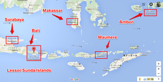
As I mentioned earlier we are not interested in the Lessor Sunda Islands either between Bali and Maumere, say, because there are non-Pelni ferries along this chain of islands. Here is the relevant map.


This chain of islands, in its own right, is an interesting route and we note with satisfaction that Denpasar and Kupang are major nodal points on this Pelni map.

In particular, we also note with pleasure that it is possibe to go from Maumere to Makassar. This was a missing link on some of other privately edited Pelni maps.

Having said that one island which is of particular interest is Ambon. We can easily single it out because all of the stories in this region started with this island in 1513.

It is also sitting right in the middle of Banda sea.

Ambon 1513

The Portuguese came to this island first in 1513. Then came the British and the Dutch and all the way across the Pacific the Spaniards. In 1623 there was a historically famous massacre on this island.

The Dutch beheaded 10 British merchants, 9 Japanese mercenary soldiers and a large number of locals and one Portuguese after torturing them by fire and amputating their legs.

Consequently, everybody got so pissed off at the Dutch atrocity and the British went away and concentrated on colonising India. The Spaniards went further north to the Phyls. The Portuguese retrieted to South America. The Japanese also went away and closed its borders.

The Dutch therefore thrived in this region of present day Indonesia for the next 300 years until they were eventually driven out by the Japanese.

So, this is a very interesting area to visit.


Ternate

By 13th century there had been a long standing and well established Islamic kingdom around Ternate before a Portuguese ship got shipwrecked there and sailors were all rescued and well looked after by the locals.

Just like the Turkish navy ship shipwrecked off the coast of Nagoya in 19th century Japan. The only difference being that the Portuguese in return quickly decided to colonise this kingdom. In so doing they were forced to killing a very large number of locals indeed. They were eventually driven out, all thanks to the Dutch, however.

That is all histroy, what we call histroy, though.

Where do we go from here?

My gut feeling is that rather than forming out a route of your own making we might just as well look at some of the existing Pelni routes and see how well or not well they might fit with what you are potentially interested in.

At Pelni they have about 25 liners and consequently there are about 25 ready-made routes to consider. So, in the next article we will be looking at some of them for scrutiny.


Pelni timetable and Banda sea - 8

2016-07-19 11:51:46 | Weblog

In order to discuss navigation in Banda sea area let us first take a look at the

 railway map of Tokyo.

With each of these routes there is a very detailed and strictly adhered to timetable, but you do not normally care about timetables. It does not matter because trains are very frequent, arriving every 3 minutes or so, anyway.

So, in practice you go to your nearest station and then move to the next station where you must change trains. At that station you will not be waiting for long before your next train arrives. You just keep repeating it till you reach your destination.

Why are we then talking about Banda sea in the first place? It is not because anything else outside Banda sea is not interesting, historically, but more importantly the Pelni route map covers a lot of Banda sea and is somewhat misleading. 

Let us now take a look at the Pelni map. It looks like this.


It looks like a network and it is one.

However, unlike Tokyo network you cannot expect an immediate transfer at any of the nodes on the network. Put simply, ships are too few and far between. That is what it boils down to.

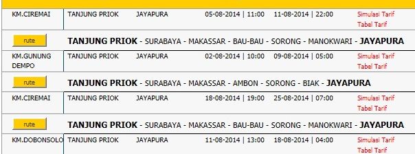
Let us take a look at a portion of the formal Pelni timetable.

Here, we are looking at the timetable for Jakarta-Jayapura leg of Pelni operation by 3 different German made boats, each carrying anything up to 4,000 passengers. You see departure and arrival times here.

Many, many moons ago I once did the Kobe-Gdainsk leg (unsure about spelling) across the Indian Ocean and round South Africa, then up and across the Bay of Biscay into Europe. There was delay in every port of call. Many reasons. Same here in Banda sea with Pelni. I am not blaming them at all.

There is another issue. Connectivity. In Tokyo, arrival at a node on one route is closely related in time to departure on another which shares the same node. Trains do not run independently of one another.

However, in Banda sea and in surrounding areas, too,  ships operate independently because it is difficult/impossible not to. Set agains this background let us now think what we normally expect from a transport network. There are many nodes on a network.

So, we naturally expect to be able to hop from one node to another without wasting too much time. With Pelni you cannot do that. Let us think about a hypothetical network with only one node.


Above is a crude model of my minimum configuration network. Since Jakarta-Jayapura takes 6 days one way both red and blue lines are 6 days long, with a nodal point in the middle. On this model you want to go from A to C via node N.

You start out from A and get off your boat at node N and wait for transfer to C  (that is all you can do) by another boat which runs along the blue line.

I am going to list the longest theoretical waiting time at N by clasification as follows.

1. 3 days: If the blue boat is between N and D and travelling towards N

2. 6 days: If the blue boat is between N and D but travelling towards D

3. 9 days : I fhe blue boat is between N and C and travelling towards N and beyond

4. 12 days: If the blue boat is between N and C but travelling towards C and beyond

So, it could take, from A to C, anything from 3+3 days to 3+12 days.

In practice it will be more complicated. Note also that what happnes at a certain node is independent of what happens at another node.

What it means is that if you have waited a maximum of 12 days at one node you may also wait for another maxium of 12 days at the next node. Very severe world, indeed and probably good for backpackers.

From reading a lot of weblogs made by Japanese backpackers I know that it is a mess in reality, complete mess. You coud even see ships coming almost everyday into the port of your waiting, going in the same direction you want.

Anyway, it is clear, from these considerations, that you cannot plan your Pelni navigation in Banda sea. You may ask then why we cannot find ship locations via internet. My gut feeling answer is that it is no good.

Situation is very fluid with each of the ships and you are also on the move, without access to internet (I will come back to this usse later).

From purely efficiency point of view you can choose a single route, wherever the starting and ending points on the route are.  For example, the starting part of Jakarta-Jayapura leg, particularly Jakarta-Surabaya portion can be omitted.

Also, unless you choose to cross Sandakan-Zamboanga route you can also omit the Kalimantan-Makassar straight. It is a recently developped lane, for oil and timbers.

OK, that is for efficiency, more or less. Another problem with Pelni ships is that they are meant to take people from A to B disregarding anything else, so they only stay at any port of call for a minimum amount of time.

What tends to happen on a typical Pelni voyage is that you keep watching tropical waters for days and days from morning till night and not experience anything at the back of each port of call.

All in all, given the spontaneous operational delay of up to a few days the best strategy and course of action in moving about in Banda sea is not to plan ahead and stay at each port of call for a few days for:

1. enjoying the stay on the island because you need a few days anyway

2. waiting for the next Pelni boat to arrive

The only other thing you must be mindful about is where and how eventually to exit from Banda sea area. This is an acute issue and I will be looking at this perennial problem with the next article.


Pelni timetable and General Santos, Mindanao - 7

2016-07-19 08:06:40 | Weblog

Title of this article has been modified to reflect its contents.

What we should know about General Santos in terms of the sea route transfer to Surawesi is put togerther in this map.

In what follows we will see that both EPA and Eaga Agro Marine are well establihsed in this warf area of General Santos.

First, let us take a look at the relative location of General Santos with a map

as follows.          My gut feeling is that it is Davao that you should come to if you are flying into the Phyls.

There are myriads of ways to get to General Santos, however. You could perhaps fly local, or even take a ferry, all the way from Cebu or even Manila, I think. Let us get 

closer.  Here, we see that the town centre of Gensan (General Santos, locally) is away from the warf area by quite a distance, something like 5 km.

                         That an airport is there is somewhat reassuring, even if it may be an air strip.

If we get even closer to the warf we see what follows.

                Let us have a loo at a satellite pictures.

 What we can see here is that both EPA and Eaga Agro Marine we have been talking about have very large buildings.

In fact, they are the most promonent buildings in the warf area along with the Philippine Ports Authority (PPA). That gives us some confidence about the integrity of their operations.

See some more photos.


                     This last image is showing us the location of the Philippine Ports Authority and in particular the entrance gates to PPA.

If we come down to the ground level we begin to see somethig like what follows.

       This is what the gates area looks like. You go in and turn left then you will see the PPT building.


There is a major junction nearby and this above photo is looking into the PPT gate area from that junction. Very far ahead you can actually see some cranes at the warf.

           This is the major junction, not terribly important on its own, though.

I will finish off with this article by looking at the town centre with a few photos.

       There is an Immigration office at the Robinsons. Satellite photo is next.


It shoud not be too difficult to locate this large structure in town. Some more

 photos follows.


There is a consulate of Papua New Guinea in General Santos, very near the warf.

However, the nearest Indonesian consulate is located in the town of Davao.