


ここは地層研究者には良く知られた場所かもしれない。
志戸前川に入ると直ぐに採石場があった。

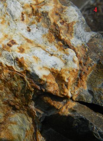
いつのものだろう。何か大事件を思わせる地層がある。

見にいきたいけど、立入禁止だ。
さらに進と、玄武岩だろうか。

西和賀と同じ、石灰岩の二次堆積。

川へ降りて、
石灰岩が溶けて溶岩と混ざった様だ。
こちらは、溶かした方、

ファーブルで見るとスーパーホットプルーム。

推定2.5億年前。
上流に進んで、

ファーブルで、

モーリー、ぬさかけの滝の溶岩に似ている。
6500万年前のホットスポットか。
粘板岩だろうか、入れないので遠くから。

以上、地図上に示す。

GPSデータが無く採石場の位置は分からないが、赤丸付近と思う。
志戸前川の東が北上島の陸地で、二次堆積があることから西は浅海だったと推理。
日本列島に衝突した時に押し上げられて山になった。
砂が大量にあることからも衝突現場に間違いない。
メモ
http://www.ekoko.jp/koz_essay4/essay031.html
http://www.museum.tokushima-ec.ed.jp/cc/42.htm
志戸前川に入ると直ぐに採石場があった。
いつのものだろう。何か大事件を思わせる地層がある。
見にいきたいけど、立入禁止だ。
さらに進と、玄武岩だろうか。
西和賀と同じ、石灰岩の二次堆積。
川へ降りて、
石灰岩が溶けて溶岩と混ざった様だ。
こちらは、溶かした方、
ファーブルで見るとスーパーホットプルーム。
推定2.5億年前。
上流に進んで、
ファーブルで、
モーリー、ぬさかけの滝の溶岩に似ている。
6500万年前のホットスポットか。
粘板岩だろうか、入れないので遠くから。
以上、地図上に示す。
GPSデータが無く採石場の位置は分からないが、赤丸付近と思う。
志戸前川の東が北上島の陸地で、二次堆積があることから西は浅海だったと推理。
日本列島に衝突した時に押し上げられて山になった。
砂が大量にあることからも衝突現場に間違いない。
メモ
http://www.ekoko.jp/koz_essay4/essay031.html
http://www.museum.tokushima-ec.ed.jp/cc/42.htm


※コメント投稿者のブログIDはブログ作成者のみに通知されます