

国立歴史民俗博物館の1-2世紀の日本列島の状況解析パネル群。
北部九州が大陸・半島との文化の導入口である一方、
水田農耕の東進に伴って人口増加が各地で発生して在来の縄文文化と
あるいは対立したり混淆したりして独自の文化圏が形成された。
しかも北部九州はあまりにも国土全体からは西に偏りすぎているのと、
稲作の好適地域は日本列島各地に散在し、分散的な地域発展を見せていた。
きのうは「出雲王権」とおぼしき日本海地域を見たが、
本州島中部の関東中部東海という列島コア地域の状況です。
西方由来の文物の流入がこれら地域でも顕著とされている。
1-2世紀には鏡や銅鐸、鉄剣などの北部九州に端を発する各種金属製品が
これら東方世界にも浸透していった。
素材や形状は北部九州に由来しつつも東方独自の形が見えてきて、
文化の受容と自己主張の両面性が見えてくる、という解説。
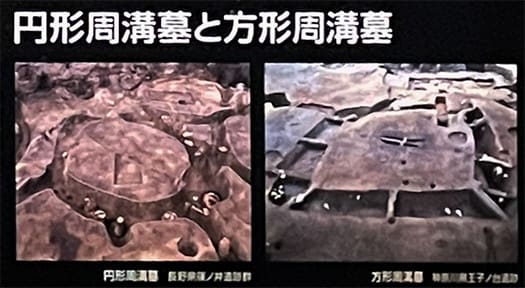
一方、墓制では円形周溝墓と方形周溝墓が営まれている。
東方日本では古来、周溝を持つ墓を営んできた。
周溝とは一種の「防衛施設」と考えるのが自然だと思うけれど、
板東という地域は、そのように荒々しい風土性を表現しているのか。
この時代からそうした地域性があって後の世に武士政権を生み出すのだろうか。
中部高地地域では円形周溝墓、東海〜関東では方形周溝墓という違い。
この周溝墓とは「共同墓域」とされているけれど、徐々に
西方からの金属製品やガラス玉などの副葬品を持った有力者の墓域が
このなかに顕在してくるようになる。
大量生産可能な稲作農業の浸透は、社会に格差を顕在化させたのだろう。
地図を詳細に見ていると、とくに関東地域での房総西部海岸、
その対岸地域としての相模地域に遺跡が集中していて、
たぶん古利根川の氾濫地域が広大に空白になっている様子が伝わる。
歴史年代になってくると「上総」は親王が守とされて
在地の最上位職は「介」とされる。古関東地域での房総の重要性がわかる。
そもそも「東海道」は三浦半島から渡海して上総に通っていたとされる。
また1-2世紀にはこの地域で赤く着色された土器が出現する。
列島各地の土器が色彩や装飾を失い簡素に実用性主体になっていくのに、
東方世界ではより強く「赤彩」を意識していたということ。
縄文土器から弥生土器に移行する大勢のなかで、どうも縄文的感受性が
一種の抵抗を見せてたようにも感じられるのだけれど、どうだろうか。
アジアの稲作農業にとって日本列島はある種、フロンティア。
後世でのヨーロッパ世界にとってのアメリカのような側面が強くあると思う。
文化的には色濃く受容しつつも、独立心は強く存在した。
朝鮮半島とはまた全然違う強い文化的求心力が働く地域だったように思える。
English version⬇
The World in the First and Second Centuries of the Kanto, Chubu, and Tokai Regions: The 37,000-Year History of the Japanese Archipelago - 42
The Japanese archipelago is the frontier of rice agriculture in Asia. It is thought that the dispersed existence of suitable land for cultivation fostered a strong culture of regional independence. The Japanese Islands
A group of panels analyzing the situation of the Japanese archipelago in the 1st and 2nd centuries at the National Museum of Japanese History.
While northern Kyushu was the entry point for the introduction of cultures from the continent and peninsulas
While northern Kyushu was a cultural gateway to the continent and peninsulas, the eastward expansion of rice paddy farming led to population growth in many areas, forming unique cultural areas that either conflicted with or intermingled with native Jomon culture.
The population growth in each region was accompanied by the eastward expansion of rice paddy agriculture, which resulted in the formation of unique cultural spheres that either conflicted or intermingled with native Jomon culture.
Moreover, Northern Kyushu is too far west of the country as a whole, and the best areas for rice cultivation are located in the Japanese archipelago.
The suitable areas for rice cultivation were scattered all over the Japanese archipelago, showing a decentralized regional development.
Yesterday, we saw the Sea of Japan region, which is considered to be the "Izumo Kingdom.
This is the situation in the core region of the archipelago, the Kanto Chubu Tokai region in the central part of Honshu Island.
The influx of cultural relics of western origin is also evident in these regions.
In the 1st and 2nd centuries, various metal products originating in northern Kyushu, such as mirrors, bronze bells, and iron swords
The materials and shapes of these objects originated in Northern Kyushu.
While the materials and shapes of these objects originated in northern Kyushu, they also had a unique form in the East.
This is a commentary on the dual nature of cultural acceptance and self-assertion.
On the other hand, in terms of the tomb system, circular and square periglottis tombs were constructed.
In Eastern Japan, tombs with ditches have been used since ancient times.
It is natural to think of peri-ditch tombs as a kind of "defense facility.
Does the region of Bando express such a rough endemic character?
Is it possible that such a regional character from this period would give rise to a warrior government in later generations?
The difference is that the Chubu Highland area has circular ditch tombs, while the Tokai to Kanto areas have square ditch tombs.
Although these periglottis tombs are considered to be "common grave sites," they are gradually being used as a place to store metal products, glass beads, and other items from the west.
The graves of influential people with metalware, glass beads, and other burial accessories from the west are gradually becoming apparent in this area.
The tombs are thought to be "communal grave sites.
The spread of mass-production rice agriculture must have brought about a disparity in society.
Looking at the map in detail, we can see that the western coast of Boso, especially in the Kanto region, and the Sagami region on the opposite coast of Boso.
The sites are concentrated in the Sagami area on the opposite coast of the Kanto region, and are probably the result of the flooding of the Ko-Tone River.
The map also shows that the flooded area of the Ko-Tone River is a large blank area.
In the historical period, "Kamihisa" was protected by the Oyashio, and the highest position in the locality was "Kuso".
The highest position in the locality is considered to be "Kozuke". This shows the importance of Boso in the old Kanto region.
It is said that the Tokaido Highway originally crossed the Miura Peninsula to reach Joso.
In the 1st and 2nd centuries, red-colored earthenware appeared in this region.
While pottery from other parts of the archipelago lost color and decoration and became simpler and more utilitarian.
While pottery from other parts of the archipelago lost color and decoration and became simpler and more utilitarian, the eastern world had a stronger awareness of "red coloring".
In the midst of the shift from Jomon to Yayoi earthenware, it seems as if Jomon sensibilities were showing a kind of resistance.
I wonder if this is because the Jomon sensibility was resisting the shift from Jomon earthenware to Yayoi earthenware.
The Japanese archipelago was a frontier for rice agriculture in Asia.
I think it has a strong aspect like America to the European world in later times.
While they were culturally accepted, they also had a strong sense of independence.
It seems to have been a region where a strong cultural centripetal force, completely different from that of the Korean peninsula, was at work.


