パエ-リャ

木製カトラリ-

Pelni timetable and Ambon/Ternate - 9

2016-07-19 16:47:56 | Weblog

In the last article I talked about general issues.

In forming ideas about possible routes it is probably best to talk about individual ports of call for reasons both for and against (mainly historical and to some extent out of geographical reasons), I think.

Only then can we visualise a few of the possiboe routes for actual travel.

With this in mind let us take another closer look at the Pelni map.

First of all, we are not interested in any of the ports west of Surabaya, except Jakarta for embarking purposes. There must be direct flights from Tokyo to both Surabaya and Bali, I think. So, Jakarta and west can be totally neglected.

As I mentioned earlier we are not interested in the Lessor Sunda Islands either between Bali and Maumere, say, because there are non-Pelni ferries along this chain of islands. Here is the relevant map.


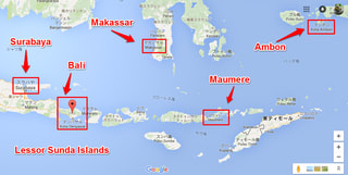
This chain of islands, in its own right, is an interesting route and we note with satisfaction that Denpasar and Kupang are major nodal points on this Pelni map.

In particular, we also note with pleasure that it is possibe to go from Maumere to Makassar. This was a missing link on some of other privately edited Pelni maps.

Having said that one island which is of particular interest is Ambon. We can easily single it out because all of the stories in this region started with this island in 1513.

It is also sitting right in the middle of Banda sea.

Ambon 1513

The Portuguese came to this island first in 1513. Then came the British and the Dutch and all the way across the Pacific the Spaniards. In 1623 there was a historically famous massacre on this island.

The Dutch beheaded 10 British merchants, 9 Japanese mercenary soldiers and a large number of locals and one Portuguese after torturing them by fire and amputating their legs.

Consequently, everybody got so pissed off at the Dutch atrocity and the British went away and concentrated on colonising India. The Spaniards went further north to the Phyls. The Portuguese retrieted to South America. The Japanese also went away and closed its borders.

The Dutch therefore thrived in this region of present day Indonesia for the next 300 years until they were eventually driven out by the Japanese.

So, this is a very interesting area to visit.


Ternate

By 13th century there had been a long standing and well established Islamic kingdom around Ternate before a Portuguese ship got shipwrecked there and sailors were all rescued and well looked after by the locals.

Just like the Turkish navy ship shipwrecked off the coast of Nagoya in 19th century Japan. The only difference being that the Portuguese in return quickly decided to colonise this kingdom. In so doing they were forced to killing a very large number of locals indeed. They were eventually driven out, all thanks to the Dutch, however.

That is all histroy, what we call histroy, though.

Where do we go from here?

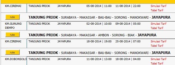
My gut feeling is that rather than forming out a route of your own making we might just as well look at some of the existing Pelni routes and see how well or not well they might fit with what you are potentially interested in.

At Pelni they have about 25 liners and consequently there are about 25 ready-made routes to consider. So, in the next article we will be looking at some of them for scrutiny.


Pelni timetable and Banda sea - 8

2016-07-19 11:51:46 | Weblog

In order to discuss navigation in Banda sea area let us first take a look at the

 railway map of Tokyo.

With each of these routes there is a very detailed and strictly adhered to timetable, but you do not normally care about timetables. It does not matter because trains are very frequent, arriving every 3 minutes or so, anyway.

So, in practice you go to your nearest station and then move to the next station where you must change trains. At that station you will not be waiting for long before your next train arrives. You just keep repeating it till you reach your destination.

Why are we then talking about Banda sea in the first place? It is not because anything else outside Banda sea is not interesting, historically, but more importantly the Pelni route map covers a lot of Banda sea and is somewhat misleading. 

Let us now take a look at the Pelni map. It looks like this.


It looks like a network and it is one.

However, unlike Tokyo network you cannot expect an immediate transfer at any of the nodes on the network. Put simply, ships are too few and far between. That is what it boils down to.

Let us take a look at a portion of the formal Pelni timetable.

Here, we are looking at the timetable for Jakarta-Jayapura leg of Pelni operation by 3 different German made boats, each carrying anything up to 4,000 passengers. You see departure and arrival times here.

Many, many moons ago I once did the Kobe-Gdainsk leg (unsure about spelling) across the Indian Ocean and round South Africa, then up and across the Bay of Biscay into Europe. There was delay in every port of call. Many reasons. Same here in Banda sea with Pelni. I am not blaming them at all.

There is another issue. Connectivity. In Tokyo, arrival at a node on one route is closely related in time to departure on another which shares the same node. Trains do not run independently of one another.

However, in Banda sea and in surrounding areas, too,  ships operate independently because it is difficult/impossible not to. Set agains this background let us now think what we normally expect from a transport network. There are many nodes on a network.

So, we naturally expect to be able to hop from one node to another without wasting too much time. With Pelni you cannot do that. Let us think about a hypothetical network with only one node.


Above is a crude model of my minimum configuration network. Since Jakarta-Jayapura takes 6 days one way both red and blue lines are 6 days long, with a nodal point in the middle. On this model you want to go from A to C via node N.

You start out from A and get off your boat at node N and wait for transfer to C  (that is all you can do) by another boat which runs along the blue line.

I am going to list the longest theoretical waiting time at N by clasification as follows.

1. 3 days: If the blue boat is between N and D and travelling towards N

2. 6 days: If the blue boat is between N and D but travelling towards D

3. 9 days : I fhe blue boat is between N and C and travelling towards N and beyond

4. 12 days: If the blue boat is between N and C but travelling towards C and beyond

So, it could take, from A to C, anything from 3+3 days to 3+12 days.

In practice it will be more complicated. Note also that what happnes at a certain node is independent of what happens at another node.

What it means is that if you have waited a maximum of 12 days at one node you may also wait for another maxium of 12 days at the next node. Very severe world, indeed and probably good for backpackers.

From reading a lot of weblogs made by Japanese backpackers I know that it is a mess in reality, complete mess. You coud even see ships coming almost everyday into the port of your waiting, going in the same direction you want.

Anyway, it is clear, from these considerations, that you cannot plan your Pelni navigation in Banda sea. You may ask then why we cannot find ship locations via internet. My gut feeling answer is that it is no good.

Situation is very fluid with each of the ships and you are also on the move, without access to internet (I will come back to this usse later).

From purely efficiency point of view you can choose a single route, wherever the starting and ending points on the route are.  For example, the starting part of Jakarta-Jayapura leg, particularly Jakarta-Surabaya portion can be omitted.

Also, unless you choose to cross Sandakan-Zamboanga route you can also omit the Kalimantan-Makassar straight. It is a recently developped lane, for oil and timbers.

OK, that is for efficiency, more or less. Another problem with Pelni ships is that they are meant to take people from A to B disregarding anything else, so they only stay at any port of call for a minimum amount of time.

What tends to happen on a typical Pelni voyage is that you keep watching tropical waters for days and days from morning till night and not experience anything at the back of each port of call.

All in all, given the spontaneous operational delay of up to a few days the best strategy and course of action in moving about in Banda sea is not to plan ahead and stay at each port of call for a few days for:

1. enjoying the stay on the island because you need a few days anyway

2. waiting for the next Pelni boat to arrive

The only other thing you must be mindful about is where and how eventually to exit from Banda sea area. This is an acute issue and I will be looking at this perennial problem with the next article.


Pelni timetable and General Santos, Mindanao - 7

2016-07-19 08:06:40 | Weblog

Title of this article has been modified to reflect its contents.

What we should know about General Santos in terms of the sea route transfer to Surawesi is put togerther in this map.

In what follows we will see that both EPA and Eaga Agro Marine are well establihsed in this warf area of General Santos.

First, let us take a look at the relative location of General Santos with a map

as follows.          My gut feeling is that it is Davao that you should come to if you are flying into the Phyls.

There are myriads of ways to get to General Santos, however. You could perhaps fly local, or even take a ferry, all the way from Cebu or even Manila, I think. Let us get 

closer.  Here, we see that the town centre of Gensan (General Santos, locally) is away from the warf area by quite a distance, something like 5 km.

                         That an airport is there is somewhat reassuring, even if it may be an air strip.

If we get even closer to the warf we see what follows.

                Let us have a loo at a satellite pictures.

 What we can see here is that both EPA and Eaga Agro Marine we have been talking about have very large buildings.

In fact, they are the most promonent buildings in the warf area along with the Philippine Ports Authority (PPA). That gives us some confidence about the integrity of their operations.

See some more photos.


                     This last image is showing us the location of the Philippine Ports Authority and in particular the entrance gates to PPA.

If we come down to the ground level we begin to see somethig like what follows.

       This is what the gates area looks like. You go in and turn left then you will see the PPT building.


There is a major junction nearby and this above photo is looking into the PPT gate area from that junction. Very far ahead you can actually see some cranes at the warf.

           This is the major junction, not terribly important on its own, though.

I will finish off with this article by looking at the town centre with a few photos.

       There is an Immigration office at the Robinsons. Satellite photo is next.


It shoud not be too difficult to locate this large structure in town. Some more

 photos follows.


There is a consulate of Papua New Guinea in General Santos, very near the warf.

However, the nearest Indonesian consulate is located in the town of Davao.