Yes, I do keep coming back to this article, because the subject is so important to many around the world and I know that there are millions (?) of people out there who want to know about PELNI operation.
http://uuu.sederet.com/translate.php
Above is an Indonesian->English dictionary, bacause you need it at some stage.
Anyway, I have been able to locate Pelni top page at long last. It is:
https://www.pelni.co.id/?lang=en
I now know why it has been so difficult for us to find Pelni top page. It is because an English version does not normally exist. Only Indonesian version is available on the Web and it only becomes available in English when you switch from Indonesian to English.
Despite the common understaiding that you cannot book with Pelni this page seems to allow you do just that.
However, as of September 2016 I am still unable to find the whole route map. I will be doing web translations here and there until I find a unified whole graphical presentation of all Pelni routes in a single page.
There is another ferry operater in Indonesia as follows.
http://www.indonesiaferry.co.id/id/home#ad-image-5 (ASDP Ferry)
This is even more difficult as there is no English version. A while ago I sent a G-mail asking for the route map they must have somewhere. I could not find one with this URL.
I have managed to decipher part of above URL myself.
http://www.indonesiaferry.co.id/id/jadwalkapal/view
This is page one of their price list. My idea was that price lists will automatically come with port names. I was dead right. Page two is next.
http://www.indonesiaferry.co.id/id/jadwalkapal/view/10
and page three as follows.
http://www.indonesiaferry.co.id/id/jadwalkapal/view/20
I have not yet examined these closely, but this last one mentions places like Ternate and Tual. Very promissing and if I open PDF.files I might even fid maps with any luck. I actually opned this last one. I did not find maps and instead found a list of routes and prices for passengers and vehicles.
The one I opened was Ternate. I was naively thinking that it was going to be a Ternate centred list of ports. I was wrong, or perhaps right, depending on how you look at it.
Ports listed are very broadly in Ternate region, but some are very far from Tarnate proper. However, it is a wealth of information about localied ferry service, as opposed to nationwide operation by PELNI.
I will be setting up a series of articles with maps for tourists from all around the globe.
In the meantime and in any event, I am still carrying all the texts I wrote before, prior to the discovery of PELNI top page as given above. They may still be useful in some ways.
At Pelni they operate 25 boats.
http://harga-promo.net/category/jadwal-kapal-pelni
This above gives you 4 pages full of boat pictures and if you click on any of these pictures it will give you relevant information.
http://hargakini.com/harga-tiket-kapal-laut-pelni/
Above URL actually gives you a list of prices. So, with this list we may be very close to the Pelni Home Page.
I now know the format for seraching for any one of these boats. Try Google search:
Pelini (boat name) (month in Indonesian) year in this order. It is the format they seem to use at Pelni. An Example is:
Pelini Kelimutu oktober 2016
This will take you to a wealth of information and you may find it difficult to see which is the most important for you. Open up a few and you should be able to get what you wanted.
What I am going to do is to provide a complete set of each Pelni route with a separate chart so that Maumere and Ambon links are all included in the set.
I will not be providing the ship time between ports let alone anchorage duration at each port as these can be easily found in the the original data set as per below.
http://goo.gl/sPRuVO
On these charts ship lines will even be crossing lands as they link two adjacent ports and charts may be divided into several parts if the area to be covered is very large.
Each chart will be named like "Pelni timetable-boat name" and not all of the port names will be given on any of the charts. Data set relate to 2016, so the charts should be fairly reliable, minus details, of course.
Altogether, there will be 25 charts, and I will be starting with Maumere linked routes and having finished with them I will then be describing 6 Ambon linked boats.
They are:
Dorolonda, Kelimuta, Nggapula, Pangrango, Sangiang, and Tidar, the last of which we already looked at a few articles ago.
In addition to above there are 16 other boats and we will be looking at what they do.
They are:
Awu, Binaiya, Ciremai, Dobonsolo, Egon, Gunung Dempo, Kelud, Labobar, Leuser, Lawit, Sinabung, Sirimaru, Tatamailau, Tilongkabila, and Wilis.
Having done all those mentioned above, my concluding remarks are as follows.
1. About Maumere linked boats none is of very much interest, perhaps mostly because I tend to think that there are local ferries along Banda chain of islands. We do not need to rely on Pelni with Banda sea chain of islands.
On the other hand it may turn out to be cheaper if you go on a single Pelni boat, rather than hopping along on different smaller boats. Another consideration is how close you are from the sea surface.
With Pelni you are so high up and you do not get the feel of the sea.
2. A few of Ambon linked boats are very interesting indeed. In fact, those of Pelni which look most intersting are more or less Ambon based.
3. Outside above, there are also a few which look interesting.
I have annotated with *s and added an additional quick glance map at the start of each note.
Interesting boats (above 4 *s) are :
1. Kelimutu (*****)
2. Nggapulu (*****)
3. Pangrango (*****)
4. Tidar (****)
5. Awu(*****)
6. Sinabung (*****)
7. Tatamailau (****)
8. Tolongkabila (*****)
9. Wilis (*****)
Further scruinity will be based on this list. More attention will be paid on port stay duration. In all above, I may be biased towards Ambon.
However, Ambon was the hub if you look back on it. Stories are associated with Ambon, more so than any other islands, except perhaps Ternate.


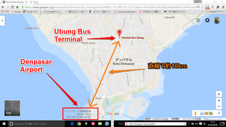
 ロンボク島側では比較的有名な Senggigi に移動するのが妥当だと思われる。矢張り、テロの危険があるので、前日の宿をクタでなく、サヌ-ルに取るだろう。この地図の付加記事に、バスの出発がペラ-マの事務所からだとあるので、準チャ-タ-バスみたいなものかも知れない。
 これが、残りの2辺の固定が始まった画面だ。小さな世界ではあるけれど、ここにもノウハウはある、厳然として、たったの1週間の作業なのに、だから、大昔の職人のノウハウは凄かったんだろうと、素朴に思う。
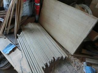
 二つ、と言うか、2枚の台箱が出来上がった。この画像がそれだ。合板の厚みは、3mmでなく、2.3mmだったので、縁取りの高さを含めても5.3mmの縁があるだけで、箱には見えない、ほとんど。
 実際に、パン切り格子を乗せてみたら、こんな感じに見える。
 もっと作らないといけないので、作業が加速している。短い辺を先に永久固着させるのがこつだ。何故かというと、接着面積がとても少ないので、45度切りをした後で、簡単に要らない部分を無理なく取り除けるからだ。
 これが、45度切りをする前に、長い辺を、4隅から、2,3cmの処でクランプ固定をしている場面で、短い辺をすでに、その短い長さ全部で固着した後の、操作だ。
 作業はどんどん続いている。送り先は多いからだ。
 極薄の合板の縁に沿って、3mm角の角材を接着するだけで、十分に目的を達することが出来るだろう。
 これがその刃だ。刃の厚みは0.3mmだ。
 まだ、2辺しか固定してないが、最終的には4辺になる。で、悪くないと思う、デザイン的にも。
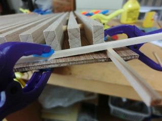
 長い辺はある程度接着が進んでいるので軽く挟んでいるだけだが、短い辺はまだなので、深く挟み込むために斜めにピンチが配置されている。数時間で解圧出来るので、ジムから戻って来れば、隅を切断して、最終処理に入れると思う。
 こんなものだろうとの思いはあったので、固着作業を始めたが、幅が大きすぎるので、別荘の離れを建設した時に使ったクランプが必要になった。作業が大変だった。これを繰り返すのなら、恐らくクランプの開口部を上向きにした、固着用のジグが必要になるだろう。


 記憶では、これの定格時間は15分だったと思うが、実際には5分程度で、60度位まで行ってしまう。その時点でトルクはほぼゼロなので、どうにもならない。
 この画像は丸ノコの刃と反対側に大きな開口部を強引に作ったことを示している。当初のは明らかに設計ミスで、空冷用の空気穴が、直径3mm程度で、6か所申訳程度にあけられていただけだった。
 これを真ん中の開口部の丸穴に取り付けて、両側の穴から排気しようとの作戦で、スマホ充電用のUSBチャ-ジャ-で駆動しようと思っている。仮に、実用定格時間が10分に伸びるだけでも、使い勝手が圧倒的によくなるからだ。


 これがそうだ。フェリ-港の名前は Benoa だ。クタ(Kuta)の繁華街も近いが爆弾テロがあった場所なので注意が必要だ。
 元々、非常にトルクが小さく、ブナの5mm程度を長さ400mm程度で切断すると、400mmx6位しか使えない。加熱して定格時間前に使えなくなるので、実際の運用は、別の作業との交互運用になってしまう。
 穴開けとの交互運用の成果もそれなりに出ている。
 それなりの成果が出ているのもうれしいことだ。
 この画像がそれだ。
 この画像で分かるように、切断の直線度の面では素晴らしい。でも、切断速度の面では、恐らく、5cmを切断するのに、5分もかかってしまう。