2大政治闘争!!
日本の政治闘争は、完全黙視(シカト)の小沢無視!
あちら(米国)は、
Haarp(?)による、ハリケーン攻撃?!
とまあ、断定は出来ないが、雰囲気的にそう言う感じだ。
それにしても、国民の生活が第一党と小沢無視は、徹底している。まあ、支持率「0%」だから、無視もするだろう。
消費税増税徹底阻止、脱原発だから、決してメディアに登場させないという戦略であろうが、甘い! 知る人は知っている。そして、敢えて拡散する次第だ。
国会も開かれているが、茶番劇には辟易しているから、見る気もしない。
ウソつきばかりが、ああでもない、こうでもないと言い合っているその腹には、一物があって、談合しているのがミエミエだ。決して、年内解散はない。だって、政党交付金が目当てであるから、するはずがない。
要するに野合の議員たちが、金算用に明け暮れているだけだ。
その中で、着々と選挙対策を講じている生活党と小沢代表には、完全無視を決め込んである。世論調査でも支持率0%とは、思い切った捏造だ。
村八分攻撃のつもりであろう。
【2012年10月29日・党本部】小沢一郎代表 定例記者会見
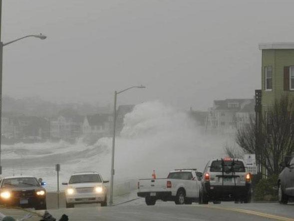
翻って、米国は大統領選挙たけなわ。ここでは熱い戦争が繰り広げられている。多分、気象兵器を用いているのであろう。これはまさに内戦だ?!
気象兵器?? と言う向きには、いい加減な話と思うであろうが、そんなのは世界の常識である。そうでなければ、かつての米ソの条約は成り立たない。気象兵器不行使の条約が存在するのである。
まずは、オバマつぶしであろう。
それにしても、急激な発達を示したハリケーン『サンディー』。奇っ怪な進路をとった『サンディー』。それだけでも疑ってかかる方が、目が見えていると言うべきだろう。井口博士もそう睨んでいるが、同感である。
博士のブログもご覧になると良い。
ジョークのような写真もあるが、それは愛嬌ということで・・・・。
上陸時のハリケーン『サンディー』。
Hurricane Sandy SRSOR Movie: 2012-Oct-29 (Landfall, Vis / IR)
【転載開始】Hurricane Sandy Life Cycle from GOES-13 October 30th, 2012
GOES-13 (GOES-East), in geostationary orbit at the Equator and 75 W longitude, was well-positioned to capture the entire lifecycle of Hurricane Sandy. An animation of 10.7 ?m IR images is shown above, at 3-hourly time steps, from incipient tropical wave, to a hurricane hitting Jamaica, to a system with an almost subtropical storm appearance off Florida. Note the relentless expansion of the system as it moves towards the northeast part of the US.
Another view of a portion of the lifecyle of Sandy is shown below, with GOES-13 6.5 ?m water vapor channel images at 1-hour intervals during the 24 October ? 30 October period. This water vapor animation is also available as a QuickTime movie.
Sandy’s final day as a hurricane over the Atlantic Ocean
October 29th, 2012The Full Moon that was exacerbating the high storm tides of Hurricane Sandy also allowed for stunning “night-time visible” imagery on 29 October 2012. A comparison of AWIPS images of Suomi NPP VIIRS 0.7 ?m Day/Night Band and 11.45 ?m IR data from shortly after 06 UTC or 2 AM EDT (above) showed the compact convective core of Hurricane Sandy east of Cape Hatteras, near the South Wall of the Gulf Stream. Sea Surface Temperature and Ocean Heat Content products from the CIMSS Tropical Cyclones site (below) indicated that later in the morning (around 12 UTC) the center of Sandy was crossing the axis of the Gulf Stream.
GOES-13 was placed into in Rapid Scan Operations (RSO) mode to monitor Sandy, and 10.7 ?m IR images (above; click image to play animation) showed several noteworthy aspects to the storm. The sheer size of the storm is quite evident. The cirrus shield of the storm was pushing west through lower Michigan into Wisconsin during the 16-hour time period of the animation. The IR images also showed the pulsing development of convection near the center of the storm, and the northwest motion of the entire system. The cyclonic circulation in the low-level wind field over the ocean and the anticyclonic circulation of the higher level clouds over the eastern United States was also apparent.
A morning overpass of the Metop-A satellite provided Advanced Scatterometer (ASCAT) winds around Sandy (below) ? there were a number of wind vectors having speeds of 50 knots or higher (within the area of red wind vectors) in the southern quadrant of the storm.
Suomi NP VIIRS 11.45 ?m, MODIS 11.0 ?m, and POES AVHRR 12.0 ?m IR images (click image to play animation)
A sequence of 1-km resolution Suomi NPP VIIRS 11.45 ?m, MODIS 11.0 ?m, and POES AVHRR 12.0 ?m IR images (above; click image to play animation) showed the structure of Hurricane Sandy at various times as it curved northwestward toward the US East Coast. Such an animation also serves to underscore the potential value of having access to high spatial resolution polar-orbiting satellite imagery in AWIPS, in the event of an outage of the GOES-East satellite (such as the one that occurred on 23 September 2012). CIMSS has the unique capability to provide such imagery from VIIRS, MODIS, and AVHRR to National Weather Service forecast offices.
During the daylight hours, GOES-14 Super Rapid Scan 0.63 ?m visible channel images at 1-minute intervals (above; click image to play HD format QuickTime movie) showed great detail in the complex temporal changes of the structure of the various cloud features associated with Sandy. Note that GOES-14 remains in SRSO-R mode, and 1-minute imagery is available here. In addition, a number of GOES-14 SRSO-R animations are available on the SSEC YouTube Channel.
Sandy made landfall as a very intense post-tropical cyclone near Atlantic City, New Jersey around 00:00 UTC on 30 October (NHC advisory archive). A large-scale POES AVHRR 12.0 ?m IR image is shown above with an overlay of the surface pressure analysis; a closer view is shown below, with surface reports and buoy reports included. The storm produced as much as 12.55 inches of rain and 29 inches of snow in Maryland, and wind gusts as high as 90 mph in New York and New Jersey (HPC storm summary).
Landfall was also captured by GOES-14 SRSO visible and IR imagery (below; also available as a QuickTime movie). Landfall occurred after sunset, so infrared imagery was an important data tool.
In spite of a brief downgrade, Sandy maintains hurricane intensity
October 27th, 2012During the overnight hours after midnight on 27 October 2012, Sandy was briefly downgraded to a Tropical Storm by the National Hurricane Center (discussion archive). A sequence of AWIPS images of 1-km resolution POES AVHRR 12.0 ?m, MODIS 11.0 ?m, and Suomi NPP VIIRS 11.45 ?m IR images (above) showed persistent pockets of deep convection north and west of the center of the tropical cyclone.
Since the Moon was in the waxing gibbous phase (at 97% of full moon phase), it provided ample illumination for a “night-time visible” image using the Suomi NPP Day/Night Band (DNB) at 06:43 UTC or 2:43 AM local time (below). A few overshooting top features could be seen in the DNB image, which corresponded with the areas of colder cloud top IR brightness temperatures seen on the VIIRS 11.45 ?m IR image at that same time.
After sunrise, GOES-14 1-minute interval SRSOR visible channel data (below; click image to play HD format QuickTime movie) showed great details of the deep convective development north and west of the partially-exposed low-level circulation center.
Additional GOES-14 SRSOR images during the afternoon hours (below; cick image to play HD format QuickTime movie) continued to show the development of convective bursts just north of the partialy-exposed low-level circulation center.
A larger-scale view using MODIS 0.65 ?m visible, 11.0 ?m IR, and 6.7 ?m water vapor channel images (below) showed the very large size of the cloud field associated with Sandy (which had re-gained hurricane intensity by this time). Also evident on the MODIS water vapor channel image was the large intrusion of dry air wrapping around the southern and eastern quadrants of Sandy, hinting at the early stages of a transition from a tropical system to an extratropical system.
An Aqua MODIS true-color Red/Green/Blue (RGB) image from the SSEC MODIS Today site (below) revealed large areas of increased turbidity in the waters just west of Florida and the Bahamas, due to mixing from the strond winds associated with Hurricane Sandy.
Finally, it was observed that there were a number of pilot reports of moderate to severe turbulence near the western periphery of the cloud shield of Sandy, where there were also hints of a transvese banding structure. Two notable pilot reports are displayed on Suomi NPP VIIRS 11.45 ?m IR and MODIS 6.7 ?m water vapor channel images (below).


