●Refill the Aral Sea
The best way to save the Aral Sea had been planned all along. When the Soviets built the Kara Kum canal system, to make up for the loss of water to the Aral Sea they intended to build two more canals to divert water from other major rivers into the Aral Basin. One canal would move water south-west from the southern flowing Volga, and another longer one would move water south by southeast from the northern flowing Ob-Irtysh. Both of these rivers are far larger than the Amu Darya and Syr Darya that water the Aral basin.
The Volga, which has its headwaters on the western slopes of the Urals, has a flow of around 240 cubic kilometers per year and flows into the Caspian Sea. The Ob-Irtysh, drawing its moisture from the vast Central Siberian Plain, has a flow of around 385 cubic kilometers per year and flows north into the Arctic Ocean. These rivers, both of which serve regions with an overabundance of water, could each have under ten percent of their flow tapped and the Aral Sea would get an extra 60 cubic kilometers per year, more than making up for the diversions that have robbed the Aral for all these years. Indeed that was the plan, fifty years ago. But the priorities of the cold war slowed Soviet investment in new canals, and when in 1989 the USSR broke up, the plan was forgotten. Until now.
Russian President Vladmir Putin, Moscow Mayor Yuri Luzhkov, and many other prominent Russian political leaders and eminent scientists are stepping forward to revive the plan to save the Aral Sea by constructing canals to tap Russian rivers. The President of Uzbekistan, Islam Karimov, has also endorsed reviving the project. The smaller of the canals was intended to transfer water from the Volga river to the Aral Sea. Today, building this canal, 800 kilometers long, 200 meters wide and 16 meters deep, would cost about (USA)$8 billion. Such a canal would tap into the Volga river in the Ural uplands, running along the contours of the earth to drain into the Aral basin and into the shrunken sea. Depending on the route, because of a lack of high altitude barriers between the Volga watershed and the Aral basin, this canal might require little or even no pumping stations.
The larger canal was designed to run from the confluence of the Ob and Irtysh rivers, 2,500 kilometers south through the lowlands along a major tributary called Tobol River, over the low hills separating the Western Siberian plain from the Aral basin. This canal, equally wide and deep while longer and requiring more pumping stations than the one built from the Volga would cost about $22 billion if it were built today. A canal from the Ob-Irtysh to the Aral Sea would be pretty big, but it is comparable in scope to canals already built all over the world. This canal system is certainly not any more extensive than the sea-killing one already in place to drain the water for crop irrigation, nor than the systems in Western Europe, California, China and elsewhere.
It is natural for many environmentalists to ridicule and demonize a plan like this. It is very expensive and constructing the canals will disrupt many local ecosystems. But the long-term benefit far outweighs costs. The biggest environmental disaster in history would be totally reversed. What's that worth? Even more compelling to environmentalists are new factors that didn't exist 50 years ago when the canal system was originally conceived. The Caspian Sea is rising alarmingly, over 2.5 meters in the last 30 years. Nobody knows where it will end. Coastal cities are at risk of inundation. Farmland is being swallowed up. Having a canal to drain 10% or more of the Volga river into the Aral Basin would help manage this crisis.
An even bigger environmental reason for building these canals applies to the Ob-Irtysh, which flows into the Arctic Ocean. Many climatologists and hydrologists are concerned about the impact of fresh water flowing into the Arctic. Their models suggest that too much fresh water might have an effect on the Gulf Stream, causing it to no longer wind its way northwards hugging Europe's western shores, from Spain to Murmansk. Weather in Europe, if no longer warmed by the Gulf Stream's tropical ocean current, would revert to an ice age. Not a pleasant thought, if you're sitting outdoors to tea in London. Melting glacial ice and icepack in recent years have allowed unprecedented levels of fresh water to accumulate in the Arctic. Diverting as many as 40 cubic kilometers of fresh water away from the Arctic delta of the Ob-Irtysh would significantly reduce the levels of fresh water in the Arctic, helping preserve the northward flowing Gulf Stream, preventing an imminent ice age.
Building two canals to save the Aral Sea, avert Caspian floods, and prevent a European ice age sound like pretty good reasons, but economic reasons also show viability. Bringing back the largest fishery in Central Asia, and having more, smarter irrigation systems would turn this desolate region, victim of man's hubris, into a garden of the world. At a cost of $30 billion, once these canals were constructed, the Aral could be refilled in twenty years. This money can be put together by the World Bank, or any collection of good-sized Nation States. This construction project could even be funded by private interests. Environmentalists should quit hiring lawyers and start buying bulldozers.
Support from the world environmental movement for refilling the Aral Sea by the only practical means, building more canals, could tip the balance, raising awareness, spreading information, and having a decisive impact on gaining sufficient global political and financial support. If Russian President Putin and others can make this their legacy, the Caspian shore will be saved, the icecaps won't melt, and ships will sail again upon the vastness and the abundance of a totally refilled Aral Sea.
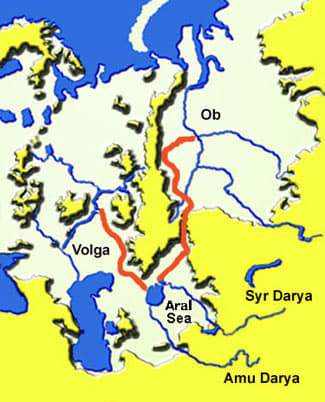
VOLGA & OB REFILL ARAL SEA:Canals (orange) divert up to 100 cubic km waterper year to the Aral Sea from the Volga & Ob Rivers. Yellow areas = elevation over 200 meters Map Scale: 100 pixels = 1,000 kilometers
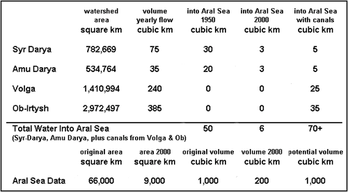
●国際河川を巡る政治経済学的分析 ―中東・中央アジア― 清水 学 伊能武次 2004
アラル海は北海道を小さくした規模の世界第4 位の表面積を誇る湖として知られていたが1960 年代以降、水表面積の縮小が続き、今日ほとんど消滅は時間の問題とされるに至っている。アラル海に流入するのはシルダリアとアムダリアの中央アジアの2 大河川であるが、その流域は全中央アジアとアフガニスタン北部にわたっている。アラル海は塩湖ではあったが大規模灌漑による流入水量の減少に伴い塩度を高め、1980 年代にアラル海の漁業がほぼ壊滅した。また流域の環境破壊もすさまじく、居住条件として悪化の一途をたどった。アラル海の水位低下や周辺の環境破壊のすべての原因が明らかにされているわけではないが、大規模灌漑による水量流入の減少が大きな原因であることは明らかである。「砂漠を緑に」という雄大なソ連邦の構想は崩壊したが、自然との共生という課題を軽視し、人間の自然改造力を過大評価したための結果である。しかし中央アジアの問題が、ソ連時代につくられた分業体制とその結果の微調整を試みてはいても、その基本的構造を変革するための条件が整っていないことである。体制移行期の経済的困難を乗り越えるためには既存の産業構造を前提に発想せざるを得ない。綿花栽培という大枠から抜け出すことは短期的には不可能であり、そのためにアラル海の縮小は継続され、また水を巡る各国の対立が緩和されない原因もそのままである。
ソ連的自然技術観のもう一つの表れは、アムダリアとシルダリアの灌漑能力を一層拡大するために議論された河川転流計画である。これはシベリアの河川水を中央アジアにまで転流させようとするもので、ブレジネフ時代に2つの転流計画が詳細に検討され、実施に移される直前まで行ったものである。最初の案は北部河川プロジェクトと呼ばれ、ヨーロッパ・ロシア北部にある河川・湖沼の水をボルガ流域に引き込もうとするものであった。第2のもっと大規模なプロジェクトは、シベリア河川転流プロジェクトで20 世紀末までにアラル海流域の灌漑地をさらに50%増加させようとするものであった。これに対する批判が公然と表明したのは、アーベル・アバンベギャンなどで、オビ河流域のエコシステムと北極海への氷供給の観点から未熟な危険な計画であると批判した。
ゴルバチョフがソ連共産党書記長になってから開かれた1986 年の第27 回党大会直前の「プラウダ」紙においても批判が現れた。異なる流域間で水資源を再配分しようとするコストの高い計画は放棄するのが望ましいと主張されたのである。これは明らかにゴルバチョフのペレストロイカあるいはグラースノスティになって初めて表明されたものである。同年8 月開かれた、ソ連共産党中央委員会と閣僚会議の合同会議で中央アジアへの河川転流プログラムを放棄し、それに代わって灌漑設備投資により水消費量を15-20%減少させる代替案が打ち出された。
●Will the Siberian rivers flow to Uzbekistan? - Pravda.Ru
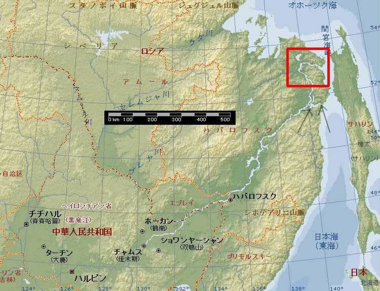
●アムール川河口(赤枠)の少し南でアムール川と間宮海峡南部の間にキジ湖という湖(灰色矢印)が存在する。間宮海峡との間には山があって繋がっていないが、その間の距離は7.5kmしかない。
【私のコメント】
ソ連時代に、西シベリアの大河の水を中央アジアの砂漠地帯に送り込んで農作物を増産するという計画が発表されたが環境破壊との批判により撤回されたと言う話はかなり有名である。しかし、最近になってこの計画が再度日の目を見ようとしているらしい。
表向きの理由は、流入河川からの過剰な取水で縮小し続けもはや消滅寸前になっているアラル海を救うため、というものだ。ロシア共和国側には自然破壊のみで何も利益が出ないとの理由で否定的な報道が多い(上記のプラウダ英語版など)。しかし、冒頭に挙げた「Refill the Aral Sea 」と題する記事では、ロシア共和国にとって死活的な利益をもたらす別の理由が紹介されている。太字の部分がそれで、『最近の気候温暖化によって北極海では氷河溶解等による淡水の供給が増加しており、それによる熱塩循環=メキシコ湾流の停止が欧州に氷河期をもたらす危険がある。シベリア大河川の淡水の一部を中央アジアに流すことでメキシコ湾流の停止を防ぐことが出来る』というものだ。
計画では、ボルガ川とオビ川の二つの河川の水をアラル海に流すための水路を建設することになっている。ボルガ川に関しては、最近の気候変化の影響かカスピ海の水位が上昇し続けており、それを元に戻すためらしい。ただ、ボルガ川は北極海には流入しないので氷河期突入防止には効果がない。効果が大きいのはオビ川やエニセイ川などの西シベリアの大河川の流路変更だろう。もし両河川から北極海への淡水供給が減少すれば、北極海の海氷形成が減少することで北極地域が温暖化すると想像される。同時にメキシコ湾流の停止防止も可能になるだろう。
現在の地球温暖化は人類が放出する二酸化炭素ではなく、太陽活動の活発化が原因であるとされていることは以前からこのブログで述べている通りだ。そして、太陽黒点周期から考えると2010-2011年頃に温暖化はピークを迎え、その後は急速に寒冷化して小氷期に突入するという仮説も存在する。歴史的に見ても地球の気候は温暖化と寒冷化を繰り返しており、近未来の小氷期突入は決してあり得ない話ではないだろう。そして、その小氷期突入を防止するための非常に有効な手段の一つとして、2010年以降にシベリア大河川流路変更計画が提案される可能性は十分考えられる。
ただ、この計画の欠点は必要とされる水路が余りに長大であり、工事期間が長引くと想像されることだ。工事完成が小氷期突入に間に合わない危険もある。もっと容易な工事はないのだろうか??
これは私の単なる思いつきで科学的検証を欠いたものだが、ユーラシア大陸東部と北米大陸東部に、容易な工事で地球を温暖化することが可能な場所があると思う。ユーラシアの工事箇所はオホーツク海に流入するアムール川の流路を変更して日本海に流入させることでオホーツク海の流氷を激減させるというものだ。アムール川下流の東側にあるキジ湖から間宮海峡南側まで、7.5kmの距離の水路工事だけでこれが可能になる。無論、日本海に流れ込むアムール川の水によって沿海州沿岸の流氷は増加するが、オホーツク海の流氷減少はそれを大きく上回る筈である。北米の工事は、セントローレンス湾に流入している五大湖の水をメキシコ湾側に流すもので、シカゴ川の拡幅などが必要になる。観光資源であったナイアガラの滝は干上がることになるが、流氷減少による北米東岸の温暖化の効果はかなり大きいと想像される。
アムール川や五大湖の水はムダに海に流すのではなく、半乾燥地帯の農業用水に使用するという方法もあるだろう。北米の場合は中西部の農業用水に充当することができる。アムール川の場合は、中国東北地方の農業用水として水を輸出することも可能である。これはロシアが水の供給によって中国の生命線を握ることを可能にするもので、戦略的価値は大きい。ただし、地球温暖化が予想外に進行した場合には水の対中輸出が不可能になる可能性もある。対中外交戦略と切り離した地球環境操作を可能にするためには、淡水の対中輸出は行わない方が賢明だろう。
The best way to save the Aral Sea had been planned all along. When the Soviets built the Kara Kum canal system, to make up for the loss of water to the Aral Sea they intended to build two more canals to divert water from other major rivers into the Aral Basin. One canal would move water south-west from the southern flowing Volga, and another longer one would move water south by southeast from the northern flowing Ob-Irtysh. Both of these rivers are far larger than the Amu Darya and Syr Darya that water the Aral basin.
The Volga, which has its headwaters on the western slopes of the Urals, has a flow of around 240 cubic kilometers per year and flows into the Caspian Sea. The Ob-Irtysh, drawing its moisture from the vast Central Siberian Plain, has a flow of around 385 cubic kilometers per year and flows north into the Arctic Ocean. These rivers, both of which serve regions with an overabundance of water, could each have under ten percent of their flow tapped and the Aral Sea would get an extra 60 cubic kilometers per year, more than making up for the diversions that have robbed the Aral for all these years. Indeed that was the plan, fifty years ago. But the priorities of the cold war slowed Soviet investment in new canals, and when in 1989 the USSR broke up, the plan was forgotten. Until now.
Russian President Vladmir Putin, Moscow Mayor Yuri Luzhkov, and many other prominent Russian political leaders and eminent scientists are stepping forward to revive the plan to save the Aral Sea by constructing canals to tap Russian rivers. The President of Uzbekistan, Islam Karimov, has also endorsed reviving the project. The smaller of the canals was intended to transfer water from the Volga river to the Aral Sea. Today, building this canal, 800 kilometers long, 200 meters wide and 16 meters deep, would cost about (USA)$8 billion. Such a canal would tap into the Volga river in the Ural uplands, running along the contours of the earth to drain into the Aral basin and into the shrunken sea. Depending on the route, because of a lack of high altitude barriers between the Volga watershed and the Aral basin, this canal might require little or even no pumping stations.
The larger canal was designed to run from the confluence of the Ob and Irtysh rivers, 2,500 kilometers south through the lowlands along a major tributary called Tobol River, over the low hills separating the Western Siberian plain from the Aral basin. This canal, equally wide and deep while longer and requiring more pumping stations than the one built from the Volga would cost about $22 billion if it were built today. A canal from the Ob-Irtysh to the Aral Sea would be pretty big, but it is comparable in scope to canals already built all over the world. This canal system is certainly not any more extensive than the sea-killing one already in place to drain the water for crop irrigation, nor than the systems in Western Europe, California, China and elsewhere.
It is natural for many environmentalists to ridicule and demonize a plan like this. It is very expensive and constructing the canals will disrupt many local ecosystems. But the long-term benefit far outweighs costs. The biggest environmental disaster in history would be totally reversed. What's that worth? Even more compelling to environmentalists are new factors that didn't exist 50 years ago when the canal system was originally conceived. The Caspian Sea is rising alarmingly, over 2.5 meters in the last 30 years. Nobody knows where it will end. Coastal cities are at risk of inundation. Farmland is being swallowed up. Having a canal to drain 10% or more of the Volga river into the Aral Basin would help manage this crisis.
An even bigger environmental reason for building these canals applies to the Ob-Irtysh, which flows into the Arctic Ocean. Many climatologists and hydrologists are concerned about the impact of fresh water flowing into the Arctic. Their models suggest that too much fresh water might have an effect on the Gulf Stream, causing it to no longer wind its way northwards hugging Europe's western shores, from Spain to Murmansk. Weather in Europe, if no longer warmed by the Gulf Stream's tropical ocean current, would revert to an ice age. Not a pleasant thought, if you're sitting outdoors to tea in London. Melting glacial ice and icepack in recent years have allowed unprecedented levels of fresh water to accumulate in the Arctic. Diverting as many as 40 cubic kilometers of fresh water away from the Arctic delta of the Ob-Irtysh would significantly reduce the levels of fresh water in the Arctic, helping preserve the northward flowing Gulf Stream, preventing an imminent ice age.
Building two canals to save the Aral Sea, avert Caspian floods, and prevent a European ice age sound like pretty good reasons, but economic reasons also show viability. Bringing back the largest fishery in Central Asia, and having more, smarter irrigation systems would turn this desolate region, victim of man's hubris, into a garden of the world. At a cost of $30 billion, once these canals were constructed, the Aral could be refilled in twenty years. This money can be put together by the World Bank, or any collection of good-sized Nation States. This construction project could even be funded by private interests. Environmentalists should quit hiring lawyers and start buying bulldozers.
Support from the world environmental movement for refilling the Aral Sea by the only practical means, building more canals, could tip the balance, raising awareness, spreading information, and having a decisive impact on gaining sufficient global political and financial support. If Russian President Putin and others can make this their legacy, the Caspian shore will be saved, the icecaps won't melt, and ships will sail again upon the vastness and the abundance of a totally refilled Aral Sea.

VOLGA & OB REFILL ARAL SEA:Canals (orange) divert up to 100 cubic km waterper year to the Aral Sea from the Volga & Ob Rivers. Yellow areas = elevation over 200 meters Map Scale: 100 pixels = 1,000 kilometers

●国際河川を巡る政治経済学的分析 ―中東・中央アジア― 清水 学 伊能武次 2004
アラル海は北海道を小さくした規模の世界第4 位の表面積を誇る湖として知られていたが1960 年代以降、水表面積の縮小が続き、今日ほとんど消滅は時間の問題とされるに至っている。アラル海に流入するのはシルダリアとアムダリアの中央アジアの2 大河川であるが、その流域は全中央アジアとアフガニスタン北部にわたっている。アラル海は塩湖ではあったが大規模灌漑による流入水量の減少に伴い塩度を高め、1980 年代にアラル海の漁業がほぼ壊滅した。また流域の環境破壊もすさまじく、居住条件として悪化の一途をたどった。アラル海の水位低下や周辺の環境破壊のすべての原因が明らかにされているわけではないが、大規模灌漑による水量流入の減少が大きな原因であることは明らかである。「砂漠を緑に」という雄大なソ連邦の構想は崩壊したが、自然との共生という課題を軽視し、人間の自然改造力を過大評価したための結果である。しかし中央アジアの問題が、ソ連時代につくられた分業体制とその結果の微調整を試みてはいても、その基本的構造を変革するための条件が整っていないことである。体制移行期の経済的困難を乗り越えるためには既存の産業構造を前提に発想せざるを得ない。綿花栽培という大枠から抜け出すことは短期的には不可能であり、そのためにアラル海の縮小は継続され、また水を巡る各国の対立が緩和されない原因もそのままである。
ソ連的自然技術観のもう一つの表れは、アムダリアとシルダリアの灌漑能力を一層拡大するために議論された河川転流計画である。これはシベリアの河川水を中央アジアにまで転流させようとするもので、ブレジネフ時代に2つの転流計画が詳細に検討され、実施に移される直前まで行ったものである。最初の案は北部河川プロジェクトと呼ばれ、ヨーロッパ・ロシア北部にある河川・湖沼の水をボルガ流域に引き込もうとするものであった。第2のもっと大規模なプロジェクトは、シベリア河川転流プロジェクトで20 世紀末までにアラル海流域の灌漑地をさらに50%増加させようとするものであった。これに対する批判が公然と表明したのは、アーベル・アバンベギャンなどで、オビ河流域のエコシステムと北極海への氷供給の観点から未熟な危険な計画であると批判した。
ゴルバチョフがソ連共産党書記長になってから開かれた1986 年の第27 回党大会直前の「プラウダ」紙においても批判が現れた。異なる流域間で水資源を再配分しようとするコストの高い計画は放棄するのが望ましいと主張されたのである。これは明らかにゴルバチョフのペレストロイカあるいはグラースノスティになって初めて表明されたものである。同年8 月開かれた、ソ連共産党中央委員会と閣僚会議の合同会議で中央アジアへの河川転流プログラムを放棄し、それに代わって灌漑設備投資により水消費量を15-20%減少させる代替案が打ち出された。
●Will the Siberian rivers flow to Uzbekistan? - Pravda.Ru
●アムール川河口(赤枠)の少し南でアムール川と間宮海峡南部の間にキジ湖という湖(灰色矢印)が存在する。間宮海峡との間には山があって繋がっていないが、その間の距離は7.5kmしかない。

【私のコメント】
ソ連時代に、西シベリアの大河の水を中央アジアの砂漠地帯に送り込んで農作物を増産するという計画が発表されたが環境破壊との批判により撤回されたと言う話はかなり有名である。しかし、最近になってこの計画が再度日の目を見ようとしているらしい。
表向きの理由は、流入河川からの過剰な取水で縮小し続けもはや消滅寸前になっているアラル海を救うため、というものだ。ロシア共和国側には自然破壊のみで何も利益が出ないとの理由で否定的な報道が多い(上記のプラウダ英語版など)。しかし、冒頭に挙げた「Refill the Aral Sea 」と題する記事では、ロシア共和国にとって死活的な利益をもたらす別の理由が紹介されている。太字の部分がそれで、『最近の気候温暖化によって北極海では氷河溶解等による淡水の供給が増加しており、それによる熱塩循環=メキシコ湾流の停止が欧州に氷河期をもたらす危険がある。シベリア大河川の淡水の一部を中央アジアに流すことでメキシコ湾流の停止を防ぐことが出来る』というものだ。
計画では、ボルガ川とオビ川の二つの河川の水をアラル海に流すための水路を建設することになっている。ボルガ川に関しては、最近の気候変化の影響かカスピ海の水位が上昇し続けており、それを元に戻すためらしい。ただ、ボルガ川は北極海には流入しないので氷河期突入防止には効果がない。効果が大きいのはオビ川やエニセイ川などの西シベリアの大河川の流路変更だろう。もし両河川から北極海への淡水供給が減少すれば、北極海の海氷形成が減少することで北極地域が温暖化すると想像される。同時にメキシコ湾流の停止防止も可能になるだろう。
現在の地球温暖化は人類が放出する二酸化炭素ではなく、太陽活動の活発化が原因であるとされていることは以前からこのブログで述べている通りだ。そして、太陽黒点周期から考えると2010-2011年頃に温暖化はピークを迎え、その後は急速に寒冷化して小氷期に突入するという仮説も存在する。歴史的に見ても地球の気候は温暖化と寒冷化を繰り返しており、近未来の小氷期突入は決してあり得ない話ではないだろう。そして、その小氷期突入を防止するための非常に有効な手段の一つとして、2010年以降にシベリア大河川流路変更計画が提案される可能性は十分考えられる。
ただ、この計画の欠点は必要とされる水路が余りに長大であり、工事期間が長引くと想像されることだ。工事完成が小氷期突入に間に合わない危険もある。もっと容易な工事はないのだろうか??
これは私の単なる思いつきで科学的検証を欠いたものだが、ユーラシア大陸東部と北米大陸東部に、容易な工事で地球を温暖化することが可能な場所があると思う。ユーラシアの工事箇所はオホーツク海に流入するアムール川の流路を変更して日本海に流入させることでオホーツク海の流氷を激減させるというものだ。アムール川下流の東側にあるキジ湖から間宮海峡南側まで、7.5kmの距離の水路工事だけでこれが可能になる。無論、日本海に流れ込むアムール川の水によって沿海州沿岸の流氷は増加するが、オホーツク海の流氷減少はそれを大きく上回る筈である。北米の工事は、セントローレンス湾に流入している五大湖の水をメキシコ湾側に流すもので、シカゴ川の拡幅などが必要になる。観光資源であったナイアガラの滝は干上がることになるが、流氷減少による北米東岸の温暖化の効果はかなり大きいと想像される。
アムール川や五大湖の水はムダに海に流すのではなく、半乾燥地帯の農業用水に使用するという方法もあるだろう。北米の場合は中西部の農業用水に充当することができる。アムール川の場合は、中国東北地方の農業用水として水を輸出することも可能である。これはロシアが水の供給によって中国の生命線を握ることを可能にするもので、戦略的価値は大きい。ただし、地球温暖化が予想外に進行した場合には水の対中輸出が不可能になる可能性もある。対中外交戦略と切り離した地球環境操作を可能にするためには、淡水の対中輸出は行わない方が賢明だろう。






※コメント投稿者のブログIDはブログ作成者のみに通知されます