


家族揃っての墓参りが明日の予定なのでその前に
お墓の清掃に行ってから桐生の山で亡くなった旧友の
13回忌慰霊のため榛東の吾妻山 830.74mに向かった。
その友人とは楚蘭山楽会の代表幹事だった故 K氏。
何故に桐生と離れた榛東の吾妻山で単独で慰霊登山
なのかは末尾に記す。
r-153で榛東村内を北上し、最近すっかり爆音の
響かないモータースポーツランドを通過し地球屋の
四つ角を左折して林道に入る。
直ぐに小さな石の鳥居、扁額は「北十二」で榛東村
指定の天然記念物とされる杉・欅・コナラ・イヌシデ
に囲まれている。

これが北十二の社。

榛東村には十二社が三か所ある。ここの北十二
の他には霞山 C.C近くに南十二。現在の表示は
「十二大権現」。

そして最後の一つはこれから行く吾妻山の登山口に
ある扁額無しの「中十二」だが林道を進んで
林道盗人越線との交点にある。ここの鳥居前に駐車。

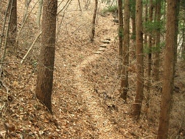
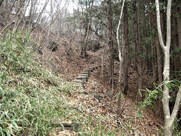
約40段の石段を登って鳥居を潜ると早速山道の雰囲気。

参道の象徴の様な石灯籠を過ぎると

再び石段、今度は45段くらい。

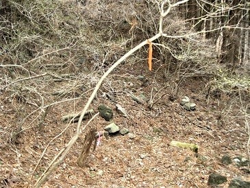
そしてこれが本殿かな?

吾妻山山頂では火を使えないと思うのでここで
一人ひっそり慰霊祭。爺イの持つK氏の唯一の
写真を飾り持参した花を供え若くして逝った
彼の無念を慰める。

この写真は2007-12に桐生明神山中で滑落死した
仲間の「極楽とんぼ」さんの慰霊祭を事件現場近くで
2008-4に桐生山の会を中心とした15名が集まった時の
集合写真。爺イもK氏の呼びかけに応じて参列した。
この時にaninecoさん・お気楽まささん・オッサンの
山旅さん・hishiyamaさんたちの知遇を得た。
右の赤シャツの大柄の人がK氏。

さて、登山再開で前進すると遊歩道の東屋。

休まず進むと初めての道標。文字は薄いが右が
「四阿」左が「遊歩道」

遊歩道は静かな林間を伸びていく。下地は柔らかく
歩き易いが谷側の肩が極めて軟弱。
やがて丸太段出現。以後このタイプの丸太段の
お世話になる。

最初の分岐、左は林道へのショートカット道なので
無視して直進。

このコース唯一の間違いやすい場所。足元ばかり見て
ホイホイと呑気に歩くと左の笹に付けられた目印を
見逃して直進してしまうが左上への笹薮に入らなくては
ならない。

笹の高みを越えると斜面を縫うように丸太段の道。
そして漸く吾妻山の名が入った道標で右へ。

直ぐに深い窪に降りて次の山波に移り南回りの
コースに入る。
其の後はこんな丸太段で山裾を右へ左へと
振り回される。

やがて左手に岩だらけの異相の山裾を回る。
これがかって群馬移動通信さんが「吾妻山の
隣にはそれより高い山があるーー」と記した
870m位の山で北コースではこれを南に乗り
越えてくる。

道はこの870m峰と吾妻山の前山の様な小突起との
鞍部に向かう。

稜線には右「吾妻山」左「富士見峠」の
道標。

大岩の脇を抜ける。左斜面には一昨日見た巨岩に
匹敵する奇岩が乱立。

小突起の乗り越えは簡単。

最後の登り道で山頂を目指す。

最後はこの大岩の右を回れば二坪ほどの
小さな山頂。
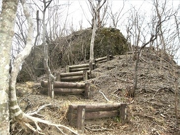
現存の標識は二枚。

ここでも写真を使ってK氏の霊に現在の吾妻山を見せた積り。

三角点は健在。四等で点名は「奥桃井」。
かつて合併前にはこの辺に確かに桃井村が
存在していたからかな?

全ての予定を終了して往路を辿って今日も無事に神社下に
帰着。

想い出
群馬県には「吾妻山」が二つある。一つは桐生で
もう一つがここの榛東村。
K氏の古い記録に「自分は桐生在住なのに桐生の
吾妻山より榛東の吾妻山が好きで数多く登っている」と
ある様に屡この山に来ていたらしい。爺イは
2006-10-10にこの山を訪れ K氏の設置した楚蘭山楽会の
標識に雨水が入って文字が滲んでいるとブログに
書いたら直ぐに返事が来て付け直すと連絡してきたのが
彼との接点の始まり。
そのすぐあと、爺イは林道の「盗人越」の由来の詮索に
励んでいて関連の「博打穴」を探した帰路に神社に寄ったら
見知らぬ人から「クタビレ爺さん?」と声をかけられた。
それが K氏だった。この時の事は彼の記事の
2006-11-13の所で「生クタビレ爺イさんに遭遇」と
題して書いてある。
其の後は彼のHPを紹介されそれまで敬遠していた
赤城方面の山々の総なめに繋がったので
aninecoさんやtomoさんと同様に
爺イの師匠の様な存在だった。すべての縁がこの
吾妻山で始まっているので13回忌はどうしても
ここで行いたかったのでそれが叶って至極満足。
お墓の清掃に行ってから桐生の山で亡くなった旧友の
13回忌慰霊のため榛東の吾妻山 830.74mに向かった。
その友人とは楚蘭山楽会の代表幹事だった故 K氏。
何故に桐生と離れた榛東の吾妻山で単独で慰霊登山
なのかは末尾に記す。
r-153で榛東村内を北上し、最近すっかり爆音の
響かないモータースポーツランドを通過し地球屋の
四つ角を左折して林道に入る。
直ぐに小さな石の鳥居、扁額は「北十二」で榛東村
指定の天然記念物とされる杉・欅・コナラ・イヌシデ
に囲まれている。
これが北十二の社。
榛東村には十二社が三か所ある。ここの北十二
の他には霞山 C.C近くに南十二。現在の表示は
「十二大権現」。
そして最後の一つはこれから行く吾妻山の登山口に
ある扁額無しの「中十二」だが林道を進んで
林道盗人越線との交点にある。ここの鳥居前に駐車。
約40段の石段を登って鳥居を潜ると早速山道の雰囲気。
参道の象徴の様な石灯籠を過ぎると
再び石段、今度は45段くらい。
そしてこれが本殿かな?
吾妻山山頂では火を使えないと思うのでここで
一人ひっそり慰霊祭。爺イの持つK氏の唯一の
写真を飾り持参した花を供え若くして逝った
彼の無念を慰める。
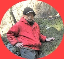
この写真は2007-12に桐生明神山中で滑落死した
仲間の「極楽とんぼ」さんの慰霊祭を事件現場近くで
2008-4に桐生山の会を中心とした15名が集まった時の
集合写真。爺イもK氏の呼びかけに応じて参列した。
この時にaninecoさん・お気楽まささん・オッサンの
山旅さん・hishiyamaさんたちの知遇を得た。
右の赤シャツの大柄の人がK氏。
さて、登山再開で前進すると遊歩道の東屋。
休まず進むと初めての道標。文字は薄いが右が
「四阿」左が「遊歩道」
遊歩道は静かな林間を伸びていく。下地は柔らかく
歩き易いが谷側の肩が極めて軟弱。
やがて丸太段出現。以後このタイプの丸太段の
お世話になる。
最初の分岐、左は林道へのショートカット道なので
無視して直進。
このコース唯一の間違いやすい場所。足元ばかり見て
ホイホイと呑気に歩くと左の笹に付けられた目印を
見逃して直進してしまうが左上への笹薮に入らなくては
ならない。
笹の高みを越えると斜面を縫うように丸太段の道。
そして漸く吾妻山の名が入った道標で右へ。
直ぐに深い窪に降りて次の山波に移り南回りの
コースに入る。
其の後はこんな丸太段で山裾を右へ左へと
振り回される。
やがて左手に岩だらけの異相の山裾を回る。
これがかって群馬移動通信さんが「吾妻山の
隣にはそれより高い山があるーー」と記した
870m位の山で北コースではこれを南に乗り
越えてくる。
道はこの870m峰と吾妻山の前山の様な小突起との
鞍部に向かう。
稜線には右「吾妻山」左「富士見峠」の
道標。
大岩の脇を抜ける。左斜面には一昨日見た巨岩に
匹敵する奇岩が乱立。
小突起の乗り越えは簡単。
最後の登り道で山頂を目指す。
最後はこの大岩の右を回れば二坪ほどの
小さな山頂。
現存の標識は二枚。
ここでも写真を使ってK氏の霊に現在の吾妻山を見せた積り。
三角点は健在。四等で点名は「奥桃井」。
かつて合併前にはこの辺に確かに桃井村が
存在していたからかな?
全ての予定を終了して往路を辿って今日も無事に神社下に
帰着。
想い出
群馬県には「吾妻山」が二つある。一つは桐生で
もう一つがここの榛東村。
K氏の古い記録に「自分は桐生在住なのに桐生の
吾妻山より榛東の吾妻山が好きで数多く登っている」と
ある様に屡この山に来ていたらしい。爺イは
2006-10-10にこの山を訪れ K氏の設置した楚蘭山楽会の
標識に雨水が入って文字が滲んでいるとブログに
書いたら直ぐに返事が来て付け直すと連絡してきたのが
彼との接点の始まり。
そのすぐあと、爺イは林道の「盗人越」の由来の詮索に
励んでいて関連の「博打穴」を探した帰路に神社に寄ったら
見知らぬ人から「クタビレ爺さん?」と声をかけられた。
それが K氏だった。この時の事は彼の記事の
2006-11-13の所で「生クタビレ爺イさんに遭遇」と
題して書いてある。
其の後は彼のHPを紹介されそれまで敬遠していた
赤城方面の山々の総なめに繋がったので
aninecoさんやtomoさんと同様に
爺イの師匠の様な存在だった。すべての縁がこの
吾妻山で始まっているので13回忌はどうしても
ここで行いたかったのでそれが叶って至極満足。


※コメント投稿者のブログIDはブログ作成者のみに通知されます