


浅間も堪能したので下山開始、さっきの東峰へルートがはっきり。
急登近道を単独氏が登ってくるがかなりの苦戦模様、下りに
使う予定もあっさりと断念。

西峰南を通過しながら振り仰ぐと裸の山。

大勢の団体さんとすれ違いながら待避所の処で峰の茶屋に到着(10.29)、

直ちに群馬側に4k戻って浅間牧場。あとで寄るからと店に断って
から駐車。店に寄らないと駐車料金を徴収と書いてあるから。

道の反対側に立ち並ぶ売店の裏に回ると牧場遊歩道への階段と
案内道標。天丸へは約2kとの表示だか実質は2.4K位(10.53)。

周りは牧場、敷地内の遊歩道を行くらしい。

左手に四阿山や本白根らしき山が見えるが良くは知らない。


「丘を越えて」の歌碑までは団体も含めてゾロゾロと人が一杯。

記念碑と説明板。昔、古賀政男の作曲を藤山一郎が歌って大流行
したこの歌の作詞者・島田芳文氏が晩年をこの地で過ごしたと
いう縁らしい。


その先は全く無人の林間一人歩きで、軽い登り。

急に周囲が開けて牧草地、体温の上昇を感じたので近くのトイレで
冷たい水で顔を冷やす。

やがて牧場用専用の舗装路にぶつかり左折、カンカン照りの
中を1.4kのアップダウン道をひたすら歩くが周囲は牧草地。

漸く白糸の滝方面へ右折、

僅かの登りで左手に道標。

その先に木段

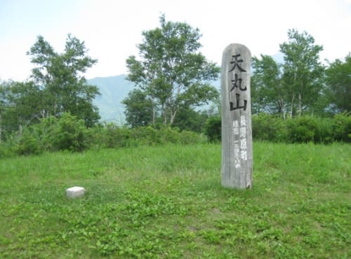
ほんの丘程度の天丸山到着(11.54)。三角点は点名・天丸で1343.79m。

極く簡単な山名方位盤もある。

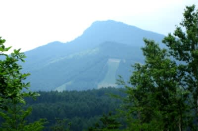
ほぼ360度の展望、浅間・四阿・白根・浅間隠・鼻曲が見えるが
霞が掛かって写真は鼻曲山の一枚のみ。
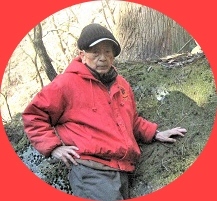
しつこくも本日三枚目の爺イ。

これは頂部に丸い突起があるので水準点なのか?

木陰で昼食休憩の後、再び炎天下の舗装道を歩いて僅かな花を見ながら
駐車場へ帰着(13.15)。


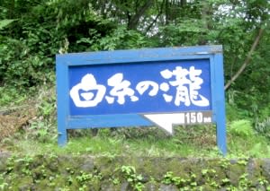
再び峰の茶屋四つ角に戻って今度は有料道路で白糸の滝へ。
この道は3k先の滝をみて軽井沢まで延々と下って300円、
決して遠くは無い滝だけを見て引き返すと440円也の不思議。
多分、滝の数キロ先で有料区間が終わっているんだろう。
売店の立ち並ぶところを中心に駐車場所は満杯(13.43)。


道標によって清流沿いの涼しい道、

団体が一杯で記念撮影で滝に近寄れず、

暫く待って漸く一枚。

帰路は途中の珍しいセパレーツ道を通って

混雑の軽井沢を見物がてらのんびり走行、軽井沢駅を西から
回り込んでからバイパス入口を素通りしてゴルフ銀座を
横目に見ながらIC入口から気に入っているR-92へ。
高岩は相変わらず凄い。あんな所に爺イが登ったとは我ながら感心。


途中で奥・裏妙義の山容を垣間見ながらR-18に合流、


松井田からは信号が少なく車も稀な旧道を使って下野尻で
再びR-18て未だ猛烈な暑さの中に帰着。
ご来訪のついでに下のバナーをポチッと。

急登近道を単独氏が登ってくるがかなりの苦戦模様、下りに
使う予定もあっさりと断念。
西峰南を通過しながら振り仰ぐと裸の山。
大勢の団体さんとすれ違いながら待避所の処で峰の茶屋に到着(10.29)、
直ちに群馬側に4k戻って浅間牧場。あとで寄るからと店に断って
から駐車。店に寄らないと駐車料金を徴収と書いてあるから。
道の反対側に立ち並ぶ売店の裏に回ると牧場遊歩道への階段と
案内道標。天丸へは約2kとの表示だか実質は2.4K位(10.53)。
周りは牧場、敷地内の遊歩道を行くらしい。
左手に四阿山や本白根らしき山が見えるが良くは知らない。
「丘を越えて」の歌碑までは団体も含めてゾロゾロと人が一杯。
記念碑と説明板。昔、古賀政男の作曲を藤山一郎が歌って大流行
したこの歌の作詞者・島田芳文氏が晩年をこの地で過ごしたと
いう縁らしい。
その先は全く無人の林間一人歩きで、軽い登り。
急に周囲が開けて牧草地、体温の上昇を感じたので近くのトイレで
冷たい水で顔を冷やす。
やがて牧場用専用の舗装路にぶつかり左折、カンカン照りの
中を1.4kのアップダウン道をひたすら歩くが周囲は牧草地。
漸く白糸の滝方面へ右折、
僅かの登りで左手に道標。
その先に木段
ほんの丘程度の天丸山到着(11.54)。三角点は点名・天丸で1343.79m。
極く簡単な山名方位盤もある。
ほぼ360度の展望、浅間・四阿・白根・浅間隠・鼻曲が見えるが
霞が掛かって写真は鼻曲山の一枚のみ。
しつこくも本日三枚目の爺イ。
これは頂部に丸い突起があるので水準点なのか?
木陰で昼食休憩の後、再び炎天下の舗装道を歩いて僅かな花を見ながら
駐車場へ帰着(13.15)。
再び峰の茶屋四つ角に戻って今度は有料道路で白糸の滝へ。
この道は3k先の滝をみて軽井沢まで延々と下って300円、
決して遠くは無い滝だけを見て引き返すと440円也の不思議。
多分、滝の数キロ先で有料区間が終わっているんだろう。
売店の立ち並ぶところを中心に駐車場所は満杯(13.43)。
道標によって清流沿いの涼しい道、
団体が一杯で記念撮影で滝に近寄れず、
暫く待って漸く一枚。
帰路は途中の珍しいセパレーツ道を通って
混雑の軽井沢を見物がてらのんびり走行、軽井沢駅を西から
回り込んでからバイパス入口を素通りしてゴルフ銀座を
横目に見ながらIC入口から気に入っているR-92へ。
高岩は相変わらず凄い。あんな所に爺イが登ったとは我ながら感心。
途中で奥・裏妙義の山容を垣間見ながらR-18に合流、
松井田からは信号が少なく車も稀な旧道を使って下野尻で
再びR-18て未だ猛烈な暑さの中に帰着。
ご来訪のついでに下のバナーをポチッと。


※コメント投稿者のブログIDはブログ作成者のみに通知されます