


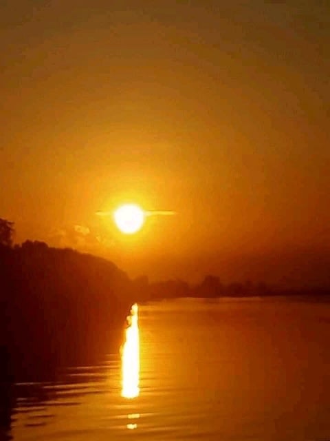
今年最後の画像は、BULCANの夕陽で終わることにしよう。
NIKKAが頑張って撮影してくれたので、大晦日まで続けられた。私は、感謝している。
日本の情報では、この街があるBULCAN州は、パンパンガ川下流域にあり、洪水の常襲地帯である。だから日本で避難計画のシミュレーションがおこなわれ学術論文(注)としてまとめられている。
実際NIKKAの家も私が知る短い期間の間に2回、床上浸水をしている。それも乾期のシーズンである。大気中へCO2の排出による地球環境の変化が、背後にありそうだ。地球環境は、少しずつ変わりだしている。
そんな懸念を抱きながら、新しい年を迎えることになりそうだ。
注)フィリピンの洪水常襲地帯における洪水氾濫解析とGISマッピング―災害対応計画作成に向けた取り組みと課題―Flood Simulation and GIS Mapping in Flood-prone Region of the Philippines: Efforts and Issues in Contingency Planning、公益社団法人 日本地理学会.E-journal GEO 11(2), 361-374, 2016
撮影及びディレクション:NIKKA PAGUTALUNAN
撮影機材:最も安価なスマートフォン
(In English)
New Year's Eve
The last image of the year will end with the BULCAN sunset.
NIKKA did his best to shoot, so I continued until New Year's Eve. I am grateful.
According to Japanese information, the state of BULCAN, where this city is located, is a flood-prone area in the lower reaches of the Pampanga River. Therefore, a simulation of the evacuation plan was carried out and summarized as an academic paper (Note1).
In fact, NIKKA's house has been flooded twice in the short period I know. It is also the dry season. Changes in the global environment due to CO2 emissions into the atmosphere are likely to be behind. The global environment is changing little by little.
With such concerns, it seems that we will enter a new year.
Note1) Naoko Nagumo, Miho Ohara, Badri Bhakta SHRESTHA, Hisaya Sawano: ―Flood Simulation and GIS Mapping in Flood-prone Region of the Philippines: Efforts and Issues in Contingency Planning, The Association of Japanese Geographers. 2), 361-374, 2016
Shooting and direction: NIKKA PAGUTALUNAN


※コメント投稿者のブログIDはブログ作成者のみに通知されます